Article
문헌 및 위성영상에 기초한 북한의 산지토사재해 발생경향 및 복구사례 분석
김기대1,
강민정2,
김석우3,4,*
Analyzing the Occurrence Trend of Sediment-Related Disasters and Post-Disaster Recovery Cases in Mountain Regions in North Korea Based on a Literature Review and Satellite Image Observations
Kidae Kim1,
Minjeng Kang2,
Suk Woo Kim3,4,*
Author Information & Copyright ▼
1Department of Forestry and Environmental System, Kangwon National University, Chuncheon 24341, Korea
2Division of Research and Survey, Korean Association of Soil and Water Conservation, Cheongju 28165, Korea
3Division of Forest Science, Kangwon National University, Chuncheon 24341, Korea
4Institute of Forest Science, Kangwon National University, Chuncheon 24341, Korea
© Copyright 2021 Korean Society of Forest Science. This is an Open-Access article distributed under the terms of the Creative Commons Attribution Non-Commercial License (http://creativecommons.org/licenses/by-nc/4.0/) which permits unrestricted non-commercial use, distribution, and reproduction in any medium, provided the original work is properly cited.
Received: Jun 02, 2021; Revised: Jul 19, 2021; Accepted: Jul 28, 2021
Published Online: Sep 30, 2021
요약
이 연구는 1960년부터 2019년까지 북한에서 발생한 산지토사재해의 시공간적 발생경향과 일부 발생 및 복구 사례를 분석하기 위하여 실시하였다. 북한의 산지토사재해 발생이력은 1995년(김정일 집권시기)부터 대외적으로 보고되기 시작하였고, 여름철 호우가 주된 유발요인으로 나타났다. 산림황폐율은 인구밀도와 밀접한 관련성(R2 = 0.4347, p = 0.02)을 보이며, 산림황폐율이 높은 서해안에서 산지토사재해 발생 보고건수가 많은 것으로 나타났다. 이는 인위적 산림훼손이 산림황폐화의 주된 원인이며, 나아가 산지토사재해 발생에도 현저한 영향을 끼쳤음을 시사한다. 위성영상을 통해 표층붕괴, 토석류 및 땅밀림 발생이 확인되었으며, 이러한 산지토사재해는 일반산지뿐만 아니라 다락밭, 채석장, 임도, 산불피해지 등 산림훼손지에서도 발생한 것으로 나타났다. 대부분의 피해지역은 복구사업의 시행 없이 존치되었지만, 일부 지역에서 산복녹화공 등의 산지사방사업 또는 사방댐, 유도둑 등의 야계사방사업을 시행한 것으로 확인되었다. 이 연구의 결과는 향후 산림복구 및 사방사업 분야의 남북 교류협력 확대에 필요한 기초정보를 제공할 수 있을 것으로 기대된다.
Abstract
This study investigated spatiotemporal trends of sediment-related disasters in North Korea from 1960 to 2019 and post-disaster recovery cases based on a literature review and satellite images. Results showed that occurrence status of sediment-related disasters was initially externally reported in 1995 (during the Kim Jongil era); their main triggering factor was heavy summer rainfall. Furthermore, forest degradation rate was positively correlated with population density (R2 = 0.4347, p = 0.02) and occurrence number of sediment-related disasters was relatively high on the west coast region, where both variables showed high values. This indicates that human activity was a major cause of forest degradation and thus, significantly affected sediment-related disasters in mountain regions. Finally, sediment-related disasters due to shallow landslides, debris flow, and slow-moving landslides were observed in undisturbed forest regions and human-impacted forest regions, including terraced fields, opencast mines, forest roads, and post-wildfire areas, via satellite image analysis. These disaster-hit areas remained mostly abandoned without any recovery works, whereas hillside erosion control work (e.g., treeplanting with terracing) or torrent erosion control work (e.g., check dam, debris flow guide bank) were implemented in certain areas. These findings can provide reference information to expand inter-Korean exchange and cooperation in forest rehabilitation and erosion control works of North Korea.
Keywords: North Korea; sediment-related disaster; forest degradation; erosion control work; spatiotemporal characteristics
서 론
1950년대에는 남한과 북한 모두 일제강점기와 한국전쟁을 겪으며 산림이 황폐한 상황이었지만, 북한은 남한에 비해 비교적 풍부한 산림자원을 보유하고 있었다(Kim, 2018). 그러나 북한은 1980년 전후 고립된 경제체제로 인해 에너지 및 식량 부족 문제에 당면하게 되어 무분별한 땔감 채취가 이루어지고, 다락밭 개간이 지속적으로 장려되었다(Jo et al., 2011; Park and Lee, 2015). 이로 인하여 1980년대부터 북한의 산림면적은 지속적으로 감소하였고(Engler et al., 2014; Choi, 2018; Dong et al., 2020), 1970년에서 1990년 사이에 약 17%가 감소하고, 1990년에서 2015년 사이에 약 40%가 감소한 것으로 추정되고 있다(North Korean Economy Watch, 2016). 그 결과, 북한의 산림훼손지수는 2012년 기준 세계 3위를 기록할 만큼 산림이 급격히 황폐되었다(Maplecroft, 2012). 산림황폐화로 인하여 북한 산림에서의 강우시 표면유출율은 1970년대 70.4%에서 2013년에는 84.0%로 증가하였고, 산지의 연간 토양유실량 역시 1990년 이전 ha당 9.3톤에서 점차 증가하여 2010년에는 18.3톤에 이르는 것으로 보고되고 있다(Kim, 2014; Park et al., 2015).
지표에 도달한 강우는 침투 후 계류로 유입되는 과정에서 지피상태와 토양의 물리적 특성에 큰 영향을 받는다(Anderson and Brut, 1990; Knighton; 1998; Seo et al., 2010). 특히 초지 및 농경지 조성에 따른 산림 벌채와 임지의 훼손은 토양의 침투능을 저하시켜 지표유출을 촉진시키는 대표적인 사례로 알려져 있다(Guzha et al., 2018; Korkanç, 2018). 지표유출의 증가는 사면침식과 이의 확대에 따른 산지토사재해를 유발하며(Kumar and Bhagavanulu, 2008; Lehmann et al., 2019), 홍수범람을 야기하기도 한다(Brandshaw et al., 2007; De la Paix et al., 2011). 결국 산림황폐화는 임지의 생산성을 저하시키고, 수원함양기능, 토사유출방지기능, 토사붕괴방지기능 등 산림의 공익적 기능 저해요인으로 작용하여 재해의 악순환을 초래할 수 있다(Park and Park, 2012; Lim et al., 2017; 2019). 북한에서 반복되는 산지토사재해 및 홍수로 인한 피해의 주된 원인 중 하나도 산림환경의 훼손으로 보고되고 있으며(Myeong et al., 2008; Park et al., 2009), 그 결과 북한은 재해에 대한 위험 및 노출도, 취약성, 대응능력으로 평가되는 위기지수 역시 2020년 기준 세계 39위로 높은 수준을 기록하였다(EU, 2020).
앞으로 북한의 산림황폐화가 지속될 경우 재해 발생 위험도의 증가뿐만 아니라 한반도의 생태축 훼손까지 이어질 우려가 있다. 따라서 북한의 국토환경 및 주민생활여건 개선을 위해서 산림복구는 상실된 생태계 기능을 회복하고, 재해 취약성을 줄일 수 있는 적절한 대응방안이 될 수 있다(Steffen et al., 2007; Stanture et al., 2014). 이를 위해서는 산림복구와 함께 산지토사재해의 예방과 저감을 위한 사방사업도 실시되어야 한다. 사방사업은 산지 및 계류에 구조물과 함께 최종적으로는 식생을 조성 도입하여 임지를 보전하고 토양의 생산·이동을 조절함으로써 산지토사재해 발생에 따른 피해를 최소화하기 위해 실시한다(Chun, 2011; Kim et al., 2019). 국내 보고에 따르면 북한에 시행되어야 할 사방사업 물량은 약 1,573천 ha 면적에 약 26조 5천억 원의 비용이 소요될 것으로 추산된바 있다(Kwon et al., 2002; Choi and Woo, 2007).
북한 산림복구의 필요성은 통일을 먼저 경험한 독일의 사례에서 찾아볼 수 있는데, 동독과 서독의 통일에 소요된 비용 중 동독의 환경 복원에 234조 원의 막대한 비용이 투입된 것으로 알려져 있다(Oh and Kim, 2020; Kim et al., 2021). 따라서 북한의 산림복구는 향후 통일에 대비하여 남한과 북한이 함께 협력하여 선결해야 하는 공동의 과제로 인식해야 한다(Myeong et al., 2008). 그러나 지금까지의 남북 산림협력은 가시적인 성과물이 도출될 수 있는 양묘나 병해충 방제에 중점을 두고 단기적으로 추진되어왔다. 미래 통일 한반도의 생태축 및 환경 보전을 위해서는 북한 산림황폐화의 원인과 함께 재해발생 및 복구 현황에 대한 파악이 무엇보다 중요하며, 이를 바탕으로 사방사업 분야의 남북협력이 추진되어야 한다.
북한의 산지토사재해 발생 및 사방사업에 대한 신뢰성 있는 공식 통계자료는 확인이 불가능한 상황으로(Ahn et al., 2010), 현재 북한의 산지토사재해 발생경향과 복구사례를 확인할 수 있는 방법은 문헌자료와 위성영상만이 유일하다. 이러한 자료는 북한의 관련 현황자료 파악에 한계가 있는 상황에서 산지토사재해의 발생시점과 지점, 규모, 복구방안에 대한 객관적인 정보를 파악할 수 있는 유효한 방법이다(Guzzetti et al., 2012; Kang et al., 2016; Juang et al., 2019). 따라서 이 연구는 문헌자료를 통해 북한의 산지토사재해 발생이력을 구축하여 산지토사재해의 시공간적 발생경향을 검토하고, 위성영상으로 산지토사재해 발생사례 및 복구방안을 파악함으로써 향후 산림복구 및 사방사업 분야 협력 확대를 위한 기초정보를 제공하기 위하여 수행하였다.
연구방법
1. 산지토사재해 발생경향
이 연구에서는 북한의 산지토사재해 발생경향을 분석하기 위해 국내외 언론보도 자료와 국내 연구보고서 등의 문헌자료를 수집하여 데이터베이스를 구축하였다. 언론보도 자료는 네이버 뉴스(http://news.naver.com/) 및 뉴스라이브러리(http://newslibrary.naver.com/), 구글(http://www.google.co.kr/)을 검색기반으로 활용하여 수집하였고, ‘북한(North Korea)’ 및 ‘조선인민민주주의공화국(Democratic People’s Republic of Korea)’과 함께 ‘산지토사재해(sediment-related disaster)’, ‘산사태(shallow landslide)’, ‘토석류(debris flow)’, ‘땅밀림(slow-moving landslide)’의 국문과 영문 키워드를 동시 검색어로 사용하였다. 보고서의 경우, 통일부 북한정보포털의 연도별 집중호우 피해현황 집계자료(MOU, 2021)와 북한 자연재난 발생이력이 정리된 연구보고서(Kang et al., 2016)를 활용하였다.
문헌자료로부터 구축된 산지토사재해 발생이력 데이터베이스는 중복성 검토를 실시한 후 연도별, 월별 및 행정구역별로 구분하여 시공간적 발생경향을 분석하였다.
2. 산지토사재해 발생 및 복구 사례
북한의 산지토사재해 발생 및 복구 사례를 분석하기 위해 구글어스 프로(Google Earth Pro Ver. 7.3)를 활용하였다. 이때, 문헌자료에서 수집된 산지토사재해 발생시기 및 지역을 중심으로 산지토사재해의 발생 여부를 식별할 수 있는 다중시기 위성영상을 수집하였다. 단, 구름 또는 적설, 그림자 등으로 지표 상태의 확인이 어려운 시기의 위성영상은 분석대상에서 제외하였다.
이상과 같이 수집된 주요 피해지역의 다중시기 위성영상을 이용하여 대표적인 산지토사재해 발생유형과 복구공종 등을 파악하였다.
결과 및 고찰
1. 산지토사재해의 발생경향
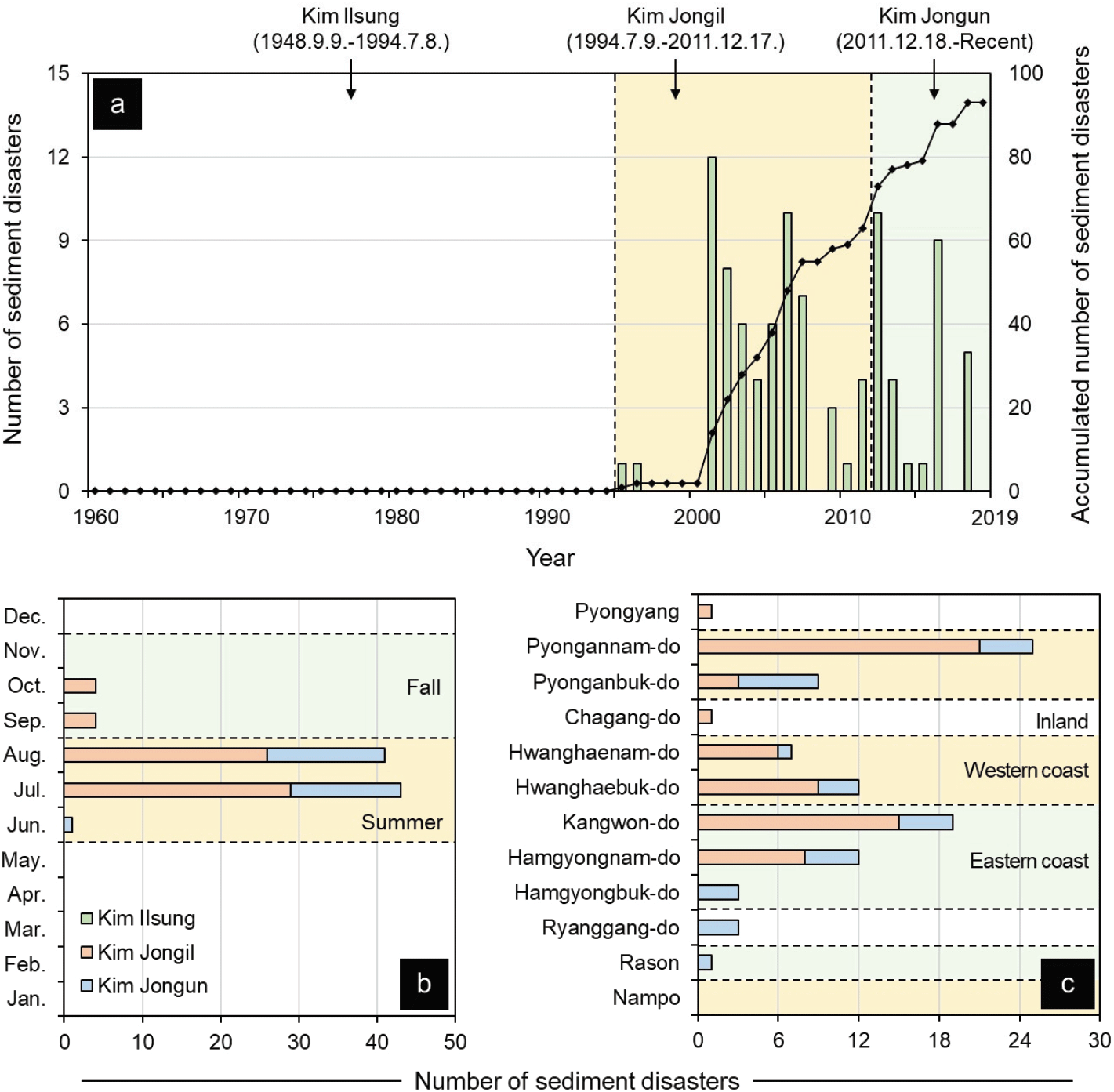
북한의 산지토사재해 발생이력을 분석한 결과, 60년(1960년∼2019년)동안 총 93건이 보고된 것으로 확인되었다(Table 1). 연도별로는 1995년에 처음으로 보고된 후 2000년대를 기점으로 점차 증가하였고, 집권시기별로는 김정일 집권시기 연평균 3.6건, 김정은 집권시기 3.7건이었으며, 김일성 집권시기에는 산지토사재해의 발생사례에 대한 보고는 없었던 것으로 나타났다(Figure 1a). 이처럼 연도 및 집권시기별 산지토사재해 보고의 변화는 당시의 시대적 상황을 반영한 것으로 추측된다. 먼저, 북한의 집권시기별 로동신문의 산림관련 보도를 살펴본 선행연구(Song et al., 2012; Yi et al., 2017)에서는 김일성 집권시기에 국가적 차원의 산림자원 생산과 이용에 대한 보도가 주를 이루었으며, 김정일 및 김정은 집권 이후 수림화·원림화 정책의 강조와 함께 산림의 보호 및 관리에 대한 보도가 주를 이루었다고 보고된바 있다. 북한의 시기별 산림관리의 정책변화를 살펴본 선행연구(Park et al., 2009; Lim, 2011) 역시 1990년대 중반 계속된 자연재해로 인해 산림황폐화에 대한 심각성을 인지하며, 산림법 제정 및 국토환경보호성을 신설하는 등 산림조성과 보호에 본격적으로 관심을 가지기 시작했다고 보고한바 있다. 이러한 결과에 따르면 1990년대 중반, 김정일 집권시기에 산림황폐화가 심각했던 것으로 추정할 수 있으며, 다수의 선행연구(Lee and Jin, 2008; Park et al., 2009; Park and Park, 2012; Lee et al., 2015)에서도 이 시기에 지속되었던 산림황폐화가 산지토사재해 및 홍수 등 자연재해 빈발의 직접적 원인으로 작용했음을 지적하였다. 한편, 김일성 집권시기에 보고된 산지토사재해의 발생사례는 확인되지 않았지만, 김정일 및 김정은 집권시기에 들어 산림황폐화가 가속화되었기 때문에 김일성 집권시기에는 상대적으로 산지토사재해 발생사례가 적었을 것으로 추정된다.
Table 1.
List of sediment-related disasters reported in North Korea from 1960 to 2019.
| No. |
Year |
Month |
Location |
| 1 |
1995 |
August |
Sinuiju-gun, Pyonganbuk-do |
| 2 |
1996 |
August |
Pyongannam-do |
| 3 |
2001 |
July |
Pyonganbuk-do |
| 4 |
2001 |
July |
Pyongannam-do |
| 5 |
2001 |
August |
Gaeseong-si, Hwanghaebuk-do |
| 6 |
2001 |
August |
Paechon-gun, Hwanghaenam-do |
| 7 |
2001 |
August |
Yonan-gun, Hwanghaenam-do |
| 8 |
2001 |
August |
Pyonggang-gun, Kangwon-do |
| 9 |
2001 |
August |
Sinhung-gun, Hamgyongnam-do |
| 10 |
2001 |
August |
Toksong-gun, Hamgyongnam-do |
| 11 |
2001 |
October |
Hamgyongnam-do |
| 12 |
2001 |
October |
Wonsan-si, Kangwon-do |
| 13 |
2001 |
October |
Anbyon-gun, Kangwon-do |
| 14 |
2001 |
October |
Tongchon-gun, Kangwon-do |
| 15 |
2002 |
August |
Pyonganbuk-do |
| 16 |
2002 |
August |
Pyongannam-do |
| 17 |
2002 |
August |
Paechon-gun, Hwanghaenam-do |
| 18 |
2002 |
August |
Chongdan-gun, Hwanghaenam-do |
| 19 |
2002 |
August |
Yonan-gun, Hwanghaenam-do |
| 20 |
2002 |
August |
Gaeseong-si, Hwanghaebuk-do |
| 21 |
2002 |
August |
Goseong-gun, Kangwon-do |
| 22 |
2002 |
August |
Tongchon-gun, Kangwon-do |
| 23 |
2003 |
August |
Pyeongyang |
| 24 |
2003 |
August |
Pyeongseong-si, Pyongannam-do |
| 25 |
2003 |
August |
Phyongwon-gun, Pyongannam-do |
| 26 |
2003 |
August |
Hwangju-gun, Hwanghaebuk-do |
| 27 |
2003 |
August |
Singye-gun, Hwanghaebuk-do |
| 28 |
2003 |
August |
Suan-gun, Hwanghaebuk-do |
| 29 |
2004 |
July |
Pukchang-gun, Pyongannam-do |
| 30 |
2004 |
July |
Chongpyong-gun, Hwanghaenam-do |
| 31 |
2004 |
July |
Cheorwon-gun, Kangwon-do |
| 32 |
2004 |
July |
Goseong-gun, Kangwon-do |
| 33 |
2005 |
July |
Deokcheon-si, Pyongannam-do |
| 34 |
2005 |
July |
Pukchang-gun, Pyongannam-do |
| 35 |
2005 |
July |
Maengsan-gun, Pyongannam-do |
| 36 |
2005 |
July |
Yangdok-gun, Pyongannam-do |
| 37 |
2005 |
July |
Sinyang-gun, Pyongannam-do |
| 38 |
2005 |
July |
Songchon-gun, Pyongannam-do |
| 39 |
2006 |
July |
Yangdok-gum, Pyongannam-do |
| 40 |
2006 |
July |
Sinyang-gun, Pyongannam-do |
| 41 |
2006 |
July |
Songchon-gun, Pyongannam-do |
| 42 |
2006 |
July |
Maengsan-gun, Pyongannam-do |
| 43 |
2006 |
July |
Goseong-gun, Kangwon-do |
| 44 |
2006 |
July |
Sepo-gun, Kangwon-do |
| 45 |
2006 |
July |
Ichon-gun, Kangwon-do |
| 46 |
2006 |
July |
Pangyo-gun, Kangwon-do |
| 47 |
2006 |
July |
Hamgyongnam-do |
| 48 |
2006 |
July |
Hwanghaebuk-do |
| 49 |
2007 |
July |
Hwanghaebuk-do |
| 50 |
2007 |
August |
Koksan-gun, Hwanghaebuk-do |
| 51 |
2007 |
August |
Jagang-do |
| 52 |
2007 |
August |
Hamgyongnam-do |
| 53 |
2007 |
August |
Yangdok-gum, Pyongannam-do |
| 54 |
2007 |
August |
Tongchon-gun, Kangwon-do |
| 55 |
2007 |
September |
Sepo-gun, Kangwon-do |
| 56 |
2009 |
July |
Kangwon-do |
| 57 |
2009 |
July |
Pyongannam-do |
| 58 |
2009 |
July |
Hamgyongnam-do |
| 59 |
2010 |
August |
Hamheung-si, Hamgyongnam-do |
| 60 |
2011 |
July |
Suncheon-si, Pyongannam-do |
| 61 |
2011 |
July |
Deokcheon-si, Pyongannam-do |
| 62 |
2011 |
July |
Pukchang-si, Pyongannam-do |
| 63 |
2011 |
August |
Gaeseong-si, Hwanghaebuk-do |
| 64 |
2012 |
July |
Pyongannam-do |
| 65 |
2012 |
July |
Pyonganbuk-do |
| 66 |
2012 |
July |
Hwanghaeanm-do |
| 67 |
2012 |
July |
Hwanghaebuk-do |
| 68 |
2012 |
July |
Kangwon-do |
| 69 |
2012 |
July |
Dancheon-si, Hamgyongnam-do |
| 70 |
2012 |
August |
Pyongannam-do |
| 71 |
2012 |
August |
Pyonganbuk-do |
| 72 |
2012 |
August |
Hwanghaebuk-do |
| 73 |
2012 |
August |
Hamgyongnam-do |
| 74 |
2013 |
July |
Wonsan-si. Kangwon-do |
| 75 |
2013 |
August |
Anju-si, Pyongannam-do |
| 76 |
2013 |
August |
Pyonganbuk-do |
| 77 |
2013 |
August |
Hyesan-si, Yanggang-do |
| 78 |
2014 |
June |
Hamgyongbuk-do |
| 79 |
2015 |
August |
Rasun |
| 80 |
2016 |
July |
Hamgyongbuk-do |
| 81 |
2016 |
July |
Hamgyongnam-do |
| 82 |
2016 |
July |
Kangwon-do |
| 83 |
2016 |
July |
Guseong-si, Pyonganbuk-do |
| 84 |
2016 |
July |
Sakchu-gun, Pyonganbuk-do |
| 85 |
2016 |
July |
Uiju-gun, Pyonganbuk-do |
| 86 |
2016 |
August |
Hamgyongbuk-do |
| 87 |
2016 |
August |
Hyesan-si, Yanggang-do |
| 88 |
2016 |
August |
Kapsan-gun, Yanggang-do |
| 89 |
2018 |
August |
Yanggang-do |
| 90 |
2018 |
August |
Hwanghaenam-do |
| 91 |
2018 |
August |
Kumchon-gun, Hwanghaebuk-do |
| 92 |
2018 |
August |
Wonsan-si, Kangwon-do |
| 93 |
2018 |
August |
Hamgyongnam-do |
Download Excel Table
Figure 1.
Temporal and spatial distribution of sediment-related disasters reported in North Korea from 1960 to 2019 (a: yearly, b: monthly c: location).
Download Original Figure
아울러 2001년, 2006년, 2012년에는 각 10건 이상의 산지토사재해가 보고되었는데, 이는 2001년 장기간에 걸친 장마와 국내에도 산지토사재해를 발생시킨 2006년 태풍 ‘에위니아(EWINIAR)’, 2012년 태풍 ‘볼라벤(BOLAVEN)’ 등으로 인한 폭우가 산지토사재해를 유발한 것으로 추측된다. 월별로 구분한 경우 7월이 43건(46.2%)으로 가장 많았으며, 8월 41건(44.1%), 9월과 10월이 각각 4건(4.3%), 6월 1건(1.1%) 순이었다(Figure 1b). 일반적으로 산지토사재해를 유발시키는 요인을 크게 강우와 지진으로 구분할 수 있는데(Chung and Rogers, 2014; Jeon and Beak, 2019), 북한에서 연강수량의 절반 이상이 집중되는 여름에(Hong, 2003; Lee et al., 2013; Myeong et al., 2013) 산지토사재해 보도가 집중되었다는 점을 고려한다면 산지토사재해의 주요 원인이 강우인 것으로 추정해볼 수 있다. 한편, 전 세계적으로 산지토사재해를 유발시킨 지진의 최소 규모는 약 4 이상으로 보고된바 있다(Keefer, 1984; 2002; Havenith et al., 2016). 북한에서 자연적으로 발생한 규모 4 이상의 지진은 총 7차례로서 모두 1990년대 전으로 보고되었으며(Korea Meteorological Administration, 2021), 이로 인한 산지토사재해 보고는 없었던 것으로 나타났다. 다만 6차 핵실험에 의한 인공지진으로 지반침하 및 융기, 산지토사재해로 추정되는 지표변위가 발생한바 있어(Lee et al., 2018; Hong et al., 2019; Baek et al., 2020), 지진에 의한 산지토사재해 발생 가능성 역시 배제할 수 없다. 더욱이 지진 발생은 산지토사재해를 유발시키는 임계강우기준의 급격한 감소를 동반하는데(Shieh et al., 2009; Chen, 2011; Gou et al., 2016; Fan et al., 2019), 인공지진으로 지반이 약해진 지역, 즉 풍계리 일대에서는 비교적 적은 강우에도 산지토사재해가 발생할 수 있었을 것으로 사료된다.
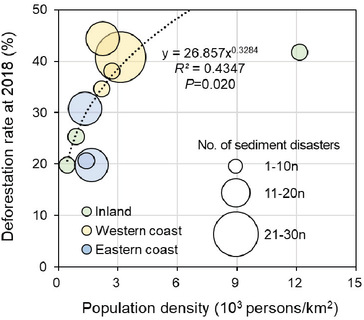
행정구역별로는 평안남도가 25건(26.9%)로 가장 많았으며, 강원도 19건(20.4%), 함경남도와 황해북도가 각각 12건(12.9%), 평안북도 9건(9.7%), 황해남도 7건(7.5%), 함경북도와 양강도가 각각 3건(3.2%), 평양직할시와 라선특별시, 자강도가 각각 1건(1.1%) 순이었다(Figure 1c). 이처럼 북한 전역에서 산지토사재해가 보고되었으며, 특히 평양직할시와 인접한 평안도 및 황해도 등 서해안 지역에 집중되었다. 일반적으로 표층붕괴 및 토석류는 사면경사가 급할수록(Woo et al., 2014), 30°이상의 급경사지에서 발생확률이 높다는 것을 고려한다면(Sidle and Ochiai, 2006) 산악지대로 이루어진 동해안 지역의 산지토사재해 발생확률이 상대적으로 높다고 할 수 있다. 그러나 비교적 완만한 지형을 이루는 서해안 지역에서 산지토사재해 발생사례가 집중적으로 보고되었던 주된 이유 중 하나는 산림황폐화라고 판단된다. 특히 북한의 산림황폐율은 인구밀도와 밀접한 관련성을 보이며(R2=0.4347, p=0.020), 산지토사재해 발생사례 보고건수가 가장 많았던 곳은 인구밀도와 산림황폐율이 높은 서해안 지역으로 확인되었다(Figure 2). 이러한 결과는 주민들의 식량 및 에너지 부족으로 인한 다락밭 개간 등의 인위적 산림훼손이 산림황폐화의 주요 원인이며, 나아가 산지토사재해 발생에도 현저한 영향을 끼쳤음을 시사한다. 실제로 관련 선행연구(Lee and Jin, 2008; Kang and Choi, 2014)에서도 서해안 지역은 평양직할시와 인접하여 인구밀도가 높은 곳으로 다락밭 조성에 따른 산림황폐화로 산림면적이 크게 감소한 것이 확인되었다. 초지와 농경지 조성에 따른 산림 벌채와 임지 훼손은 산지토사재해 발생 증가의 원인으로 지적되어 왔으며(Glade, 2003; Vanacker et al., 2003; Petley, 2010; Bruschi et al., 2013; Reichenbach et al., 2014; Soma and Kubota, 2017), 이러한 이유로 북한 전체의 사방사업 대상지 면적 중 서해안 지역은 동해안 지역에 비해 약 3배 정도 많은 것으로 보고되고 있다(Kwon et al., 2002; Choi and Woo, 2007).
Figure 2.
Number of reported sediment-related disasters for the relationship between population density and deforestation rate in North Korea. The population density and deforestation rate data source is Kim et al.(2020).
Download Original Figure
2. 산지토사재해 발생 및 복구사례
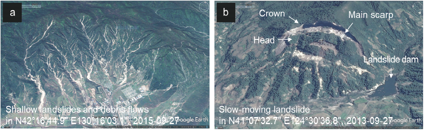
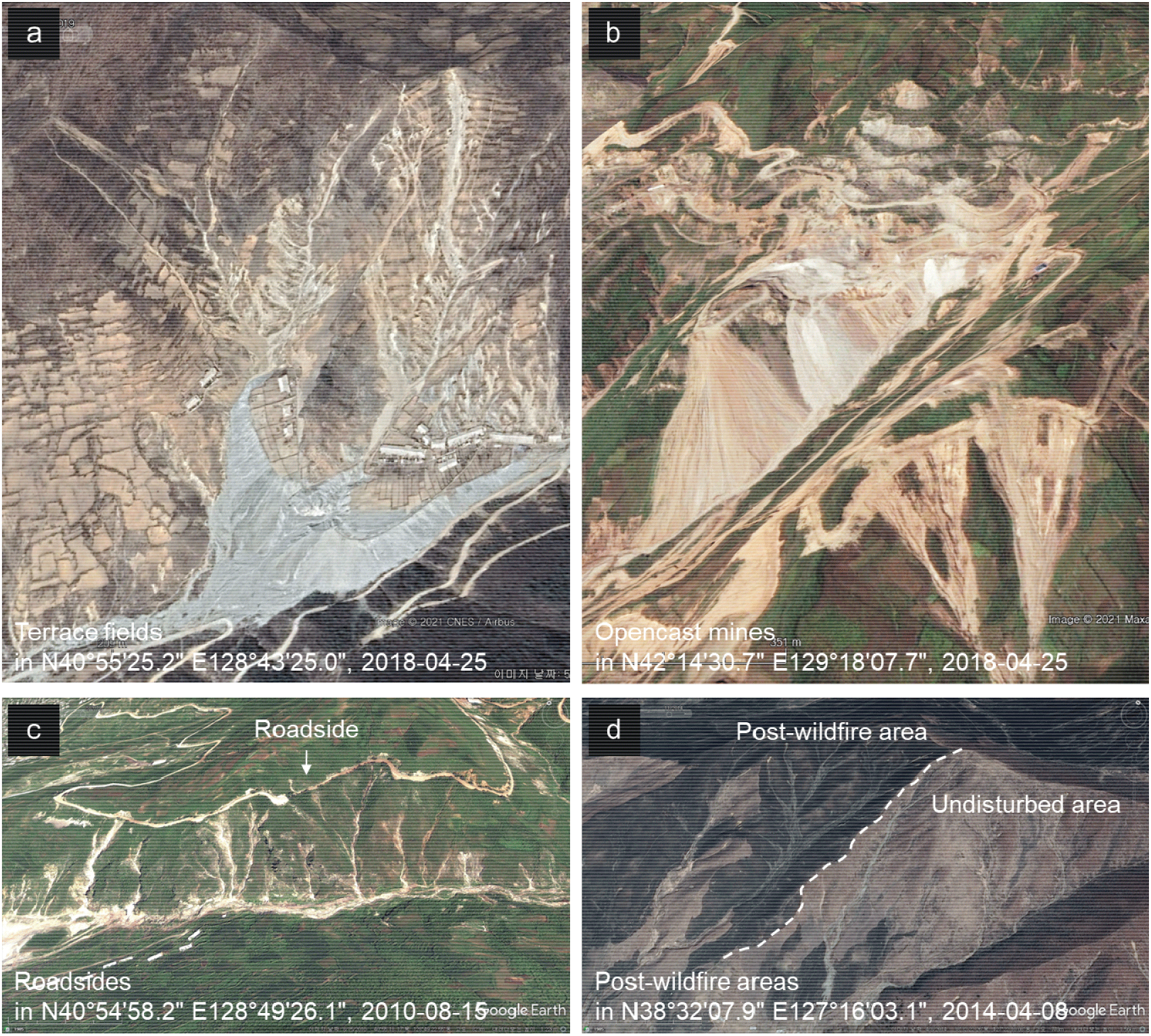
구글어스 프로의 위성영상 분석 결과, 대표적인 유형으로 동시다발적 발생으로 추정되는 표층붕괴와 토석류를 비롯하여 땅밀림으로 추정되는 대규모 사면변위와 활락애(滑落崖, Main scarp), 이로 인해 하류에 형성된 폐색호(閉塞湖, landslide dam)도 확인되었다(Figure 3). 또한 일반 산지뿐만 아니라 다락밭, 채석장, 임도 개설지, 산불피해지 등 훼손지역에서도 산지토사재해가 발생한 것을 확인할 수 있었다(Figure 4). 이는 국내에서 발생하는 대표적인 산지토사재해 발생유형(Lee et al., 2014)과 유사하였는데, 비록 각 사례에 대한 구체적인 발생정보가 없어 정확한 비교에는 한계가 있지만, 전술한 바와 같이 산림의 인위적 훼손이 산지토사재해 발생에 영향을 끼쳤을 것으로 추측된다. 특히 산림의 인위적 훼손은 지상부의 식생, 지하부의 근계 및 토양에 악영향을 동반하는데, 이러한 훼손이 사면안정성 저하에 기인한 것으로 판단된다(Glade, 2003; Porter et al., 2008; Reichenbach et al., 2014; Chen et al., 2019).
Figure 3.
Examples of sediment-related disasters due to slope failure in North Korea observed by Google Earth (a: shallow landslides and debris flows, b; slow-moving landslide).
Download Original Figure
Figure 4.
Examples of sediment-related disaster due to human activity in North Korea observed by Google Earth (a: terrace fields, b: opencast mines, c: roadsides, d: post-wildfire areas).
Download Original Figure
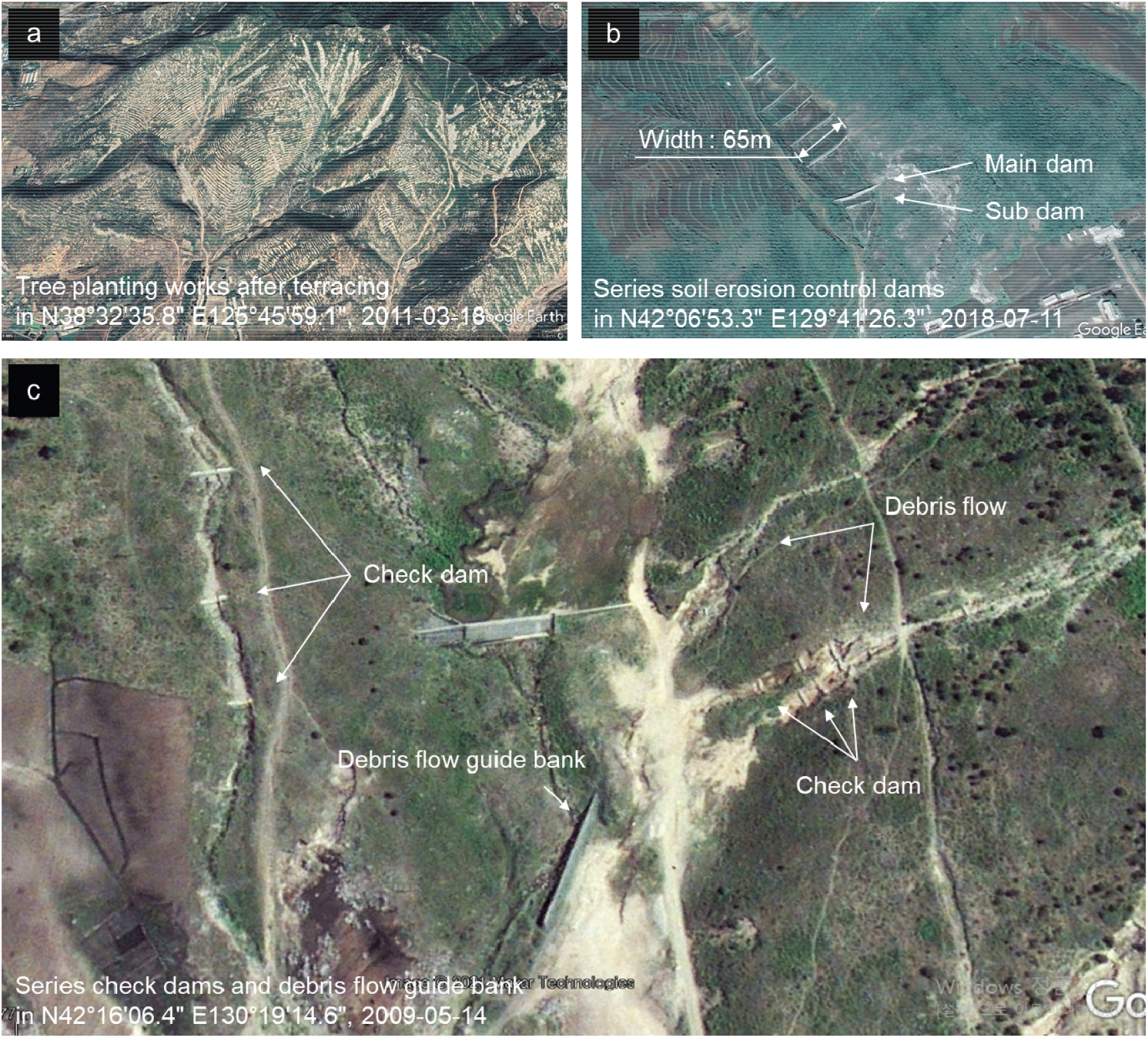
대부분의 산지토사재해 발생지는 복구사업이 시행되지 않은 채로 존치되고 있는 것으로 확인되었다. 일부 복구가 실시된 지역에서는 산복녹화공 등의 산지사방사업 또는 횡구조물 등을 이용한 야계사방사업이 시행된 것을 드물게 확인할 수 있었다. 산지사방사업의 대표적인 사례로 산지토사재해로 훼손된 사면에 비탈다듬기 및 단끊기를 실시하여 소단을 조성한 후 수목을 식재한 것이 확인되었다(Figure 5a). 야계사방사업의 대표적인 사례로는 상류에서부터 하류로 이어지도록 사방댐(Figure 5b) 및 골막이를 계통적으로 시공하였고, 유역 출구에는 토석류를 목표지점까지 안전하게 유하시키기 위한 유도둑을 시공한 것도 확인되었다(Figure 5c). 이외에도 북한에서 발행된 림업기술문답집(산림편)과 산림총서에 다양한 사방공법의 개요 및 시공방안이 소개되었는데(Ahn et al., 2010; Kim et al., 2019), 이 연구의 위성영상 분석을 통해 제한적이지만 산지사방사업이나 야계사방사업의 실례가 확인되었다. 다만 북한이 ‘2019∼2030 국가재해위험감소전략’의 일환으로 사방사업을 강조하고 있음에도 불구하고(Choi and Lim, 2021; Democratic People’s Republic of Korea, 2021), 사방사업의 시행이 부진했던 근본적인 원인은 대책기술의 부재보다는 시공재료로서의 자원 및 기술 인력의 부족에 있다고 판단된다(Ahn et al., 2010; Park et al., 2019).
Figure 5.
Examples of erosion control works in North Korea observed by Google Earth (a: tree planting works after terracing, b: a series of check dams, c: a series of check dams and debris flow guide bank).
Download Original Figure
한편, 최근 북한에서도 무분별한 토지이용 변화에 대한 심각성을 인지하고, 황폐화된 산림을 복구하기 위한 국가적 ‘산림복구전투’를 지시하였다. 동시에 식량 생산성을 향상시키기 위해 2003년 스위스개발협력청으로부터 경사지 관리 프로그램, 즉 임농복합경영을 도입하였다(He and Xu, 2017; Oh et al., 2020). 이와 관련하여 토양침식 방지를 임농복합경영의 세부 목표로 설정하고, 족제비싸리, 아까시나무, 뽕나무, 호두나무, 포플러, 기름밤나무를 토양침식 방지 수종으로 선정(He et al., 2015)하는 등 산림복구에 적극적인 노력을 보였다.
결 론
이 연구는 문헌자료를 통해 지난 60년간 북한에서 발생한 산지토사재해의 시공간적 발생경향을 분석하고, 위성영상을 이용하여 산지토사재해 발생 및 복구사례를 파악하였다. 그 결과, 북한의 산지토사재해 발생사례는 김정일 집권시기부터 대외적으로 보고되기 시작하였는데, 여름철의 태풍과 집중호우가 주된 유발요인이었던 것으로 사료된다. 다만 산림황폐율이 인구밀도와 밀접한 관련성을 보이며, 인구밀도와 산림황폐율이 높은 서해안에서 산지토사재해 발생 보고가 가장 많았다는 측면에서는 인위적인 산림훼손이 잠재적인 재해위험요인으로 작용했다고 판단된다. 한편, 위성영상을 통해 일반산지뿐만 아니라 다락밭, 채석장, 임도, 산불피해지에서의 산지토사재해 발생사례를 확인하였으며, 대표적인 유형으로 표층붕괴, 토석류 및 땅밀림이 확인되었다. 대부분의 피해지역은 복구사업의 시행 없이 존치되었지만, 일부 지역에서 산복녹화공 등의 산지사방사업이나 사방댐, 유도둑 등의 야계사방사업을 시행한 것이 확인되었다.
비록 이 연구는 불가피하게 시공간적으로 제한된 정보에 의존하였지만, 북한 산지토사재해 발생의 유발요인이나 내적요인을 직·간접적으로 파악하고, 산지사방사업과 야계사방사업의 실례를 확인할 수 있었다. 이 연구결과가 한반도 생태축 보전과 통일에 대비한 북한 황폐지 복구의 남북협력 추진을 위해 선결해야 할 현황분석에 유용한 자료가 될 수 있기를 기대한다.
감사의 글
이 연구는 산림청(한국임업진흥원) “산림과학기술 연구개발사업(2021342B10-2123-CD01)”의 지원으로 수행되었으며, 산림청 “남북산림협력 연구논문 공모전”의 일부 연구결과를 수정·보완하여 발전시킨 논문입니다.
References
Ahn, S.J., Lim, S.J., Hong, J.Y. and Kim, D.Y. 2010. Research of erosion control technique and Erosion control works propulsion performance in North Korea. Journal of Korea Society of Forest Engineering and Technology 8(1): 71-82.

Anderson, M.G. and Burt, T.P. 1990. Process studies in hillslope hydrology: an overview. pp. 1-8. In: M.G. Anderson and T.P. Brut, ed. Process studies in hillslope hydrology. John Wiley & Sones Ltd. Chichester, U.K.
Beak, W.K., Jung, H.S. and Kim, T.S. 2020. Satellite radar observation of large surface collapses induced by the 2017 North Korea nuclear test. Scientific Reports 9(1): 5124.

,

,

Bradshaw, C.J., Sodhi, N.S., Peh, K.S.H. and Brook, B.W. 2007. Global evidence that deforestation amplifies flood risk and severity in the developing world. Global Change Biology 13(11): 2379-2395.
Bruschi, V.M., Bonachea, J., Remondo, J., Gómez-Arozamena, J., Rivas, V., Barbieri, M., Capocchi, S., Soldai, M. and Cendrero, A. 2013. Land management versus natural factors in land instability: some examples in northern Spain. Environmental Management 52(2): 398-416.
,
Chen, J.C. 2011. Variability of impact of earthquake on debris-flow triggering conditions: case study of Chen-Yu-Lan watershed, Taiwan. Environmental Earth Sciences 64(7): 1787-1794.
Chen, L., Guo, Z., Yin, K., Shrestha, D.P. and Jin, S. 2019. The influence of land use and land cover change on landslide susceptibility: a case study in Zhushan Town, Xuan’en County (Hubei, China). Natural Hazards and Earth System Sciences 19(10): 2207-2228.
Choi, H.A. 2018. Prospect and implementation strategy of the inter-Korean forest cooperation: a case study of international organization support project in DPRK. Unification Policy Studies 27(2): 1-20.
Choi, H.A. and Lim, C.H. 2021. Forest cooperation with North Korea based on analysis of the characteristics of North Korea’s forest research. Review of North Korean Studies. pp. 88-111.
Choi, I.H. and Woo, J.C. 2007. Developmental process of forest policy direction in Korea and present status of forest desolation in North Korea. Journal of Forest Science 23(1): 35-49.
Chun, K.W. 2011. New erosion control engineering. Hyangmunsa. Seoul, Republic of Korea. pp. 427.
Chung, J.W. and Rogers, J.D. 2014. Landslide susceptibility as a function of fluctuating groundwater levels and seismic loading. Journal of The Korean Society of Hazard Mitigation 14(5): 115-121.
De la Paix, M.J., Lanhai, L., Xi, C., Ahmed, S. and Varenyam, A. 2013. Soil degradation and altered flood risk as a consequence of deforestation. Land Degradation & Development 24(5): 478-485.
Democratic People’s Republic of Korea. 2021. Democratic People’s Republic of Korea voluntary national review on the implementation of the 2030 agenda. pp. 63.
Dong, Y., Ren, Z., Wang, Z., Yu, Q., Zhu, L., Yu, H. and Bao, G. 2020. Spatiotemporal patterns of fchanges in Korean peninsula using landsat images during 1990-2015: a comparative study of two neighboring countries. IEEE Access 8: 73623-73633.
Engler, R., Teplyakov, V. and Adams, J.M. 2014. An assessment of forest cover trends in South and North Korea, from 1980 to 2010. Environmental Management 53(1): 194-201.
,
Fan, X., Scaringi, G., Korup, O., Wset A.J., Wseten, C.J.V., Tanyas, H., Hovius, N., Hales, T.C., Jibson, R.W., Allstadt, K.E., Zhangm L., Evans, S.G., Xu, C., Li, G., Pei, X., Xu, Q., Huang, R. 2019. Earthquake‐induced chains of geologic hazards: ratterns, mechanisms, and impacts. Reviews of Geophysics 57(2): 421-503.
Glade, T. 2003. Landslide occurrence as a response to land use change: a review of evidence from New Zealand. Catena 51(3-4): 297-314.
Guo, X., Cui, R., Li, Y., Fan, J., Yan, Y. and Ge, Y. 2016. Temporal differentiation of rainfall thresholds for debris flows in Wenchuan earthquake-affected areas. Environmental Earth Sciences 75(2): 109.
Guzha, A.C., Rufino, M.C., Okoth, S., Jacobs, S. and Nóbregae, R.L.B. 2018. Impacts of land use and land cover change on surface runoff, discharge and low flows: Evidence from East Africa. Journal of Hydrology: Regional Studies 15: 49-67.
Guzzetti, F., Mondini, A.C., Cardinali, M., Fiorucci, F., Santangleo, M. and Chag, K.T. 2012. Landslide inventory maps: New tools for an old problem. Earth-Science Reviews 112(1–2): 42-66.
Havenith, H.B., Torgoev, A., Braun, A., Schlögel, M. and Micu, M. 2016. A new classification of earthquake-induced landslide event sizes based on seismotectonic, topographic, climatic and geologic factors. Geoenvironmental Disasters 3: 6.
He, J., Ho, M.H. and Xu, J. 2015. Participatory selection of tree species for agroforestry on sloping land in North Korea. Mountain Research and Development 35(4): 318-327.
He, J. and Xu, J. 2017. Is there decentralization in North Korea? Evidence and lessons from the sloping land management program 2004-2014. Land Use Policy 61: 113-125.
Hong, I.P. 2003. North Korea’s meteorological disasters and disaster countermeasures. Water and Future 36(6): 111-114.
Hong, T.K., Lee, J.H., Park, S.J., Yoon, H.H., Kim, W.H. and Shin, J.S. 2019. Seismic detection of strong ground motions by MW5.6 North Korean nuclear explosion. Scientific Report 9(1): 5124.
,
,
Jeon, S.K. and Beak, S.C. 2019. Comparison of prediction models for identification of areas at risk of landslides due to earthquake and rainfall. Journal of the Korean Geo-Environmental Society 20(6): 15-22.
Jo, J.H., Koo, J.C. and Youn, Y.C. 2011. Economic feasilbility of REDD project for preventing deforestation in North Korea. Journal of Korean Society of Forest Science 100(4): 630-638.
Juang, C.S., Stanley, T.A. and Kirschbaum, D.B. 2019. Using citizen science to expand the global map of landslides: introducing the cooperative open online landslide repository (COOLR). PLOS ONE 14(7): e0218657.
,
,
Kang, K.T. Jang, H., Lee, J.S., Park, Y.H., Chu, J.M., Ham, S.H. and Jung. K.W. 2016. Data collection for natural disaster management in the Democratic People’s Republic of Korea and cooperation between the two Koreas(Ⅰ). Korea Environment Institute. Sejong, Republic of Korea. pp. 152.
Kang, S. and Choi, W. 2014. Forest cover changes in North Korea since the 1980s. Regional Environmental Change 14(1): 347-354.
Keefer, D.K. 1984. Landslides caused by earthquakes. Geological Society of America Bulletin 95(4): 406-421.
Keefer, D.K. 2002. Investigating landslides caused by earthquakes – a historical review. Surveys in Geophysics 23(6): 473-510.
Kim, E.H., Yang, A.R., Lim, J.B., Kim, K.M., Oh, S.U., Park, S.H. and Kim, M.K. 2021. A study on integrated forest management plan for the realization of the Korean Peninsula. National Institute of Forest Science. Seoul, Republic of Korea. pp. 124.
Kim, J.C. 2014. A review of slope land degradation in North Korea and strengthening the ability of soil erosion control. International workshop on restoration of degraded forests and sustainable forest management. Shenyang, China.
Kim, K.D., Kang, M.J., Kim, D.Y., Lee, C.W., Woo, C.S. and Seo, J.P. 2019. Research trends on soil erosion control engineering in North Korea. Journal of Korean Society of Forest Science 108(4): 496-483.
Kim, K.M. 2018. Comparison of forest changes in South and North Koreas after the Korean war and North Korea’s forest restoration strategy after Kim Jong-un era. National Institute of Forest Science. Seoul, Republic of Korea. pp. 27.
Kim, K.M., Lim, J.B., Kim, E.H., Yang, A.R., Kim, S.l., Park, J.W. and Park, J.W. 2020. Development of a method of constructing North Korean forest information using satellite imagery and AI. National Institute of Forest Science. Seoul, Republic of Korea. pp. 175.
Knighton, A.D. 1998. Fluvial forms and processes: a new prespective. 1st ed. Arnlod, London, U.K. pp. 393.
Korkanç, S.Y. 2018. Effects of the land use/cover on the surface runoff and soil loss in the Niğde-Akkaya Dam Watershed, Turkey. CATENA 163: 233-243.
Kumar, S.V. and Bhagavanulu, D.V.S. 2008. Effect of deforestation on landslides in Nilgiris district—a case study. Journal of the Indian Society of Remote Sensing 36(1): 105-108.
Kwon, T.J., Jung, J.K., Kim, Y.H., Jeon, H.J., Jeon, M.K., Jung, H.C., Lee, J.C., Lim, S.K., Hong, S.Y., Jung, S.J., Park, Y.S., Lee, S.H., Kim, C.M. and No, D.K. 2002. A study on the status of agricultural infrastructure and its renovation in North Korea. Ministry of Agriculture Food and Rural Affairs. Sejong. Republic of Korea. pp. 501.
Lee, B.R., Chun, E.S., Kim, T.W. and Kwon, H.H. 2013. Comparison of precipitation characteristics using rainfall indicators between North and South Korea. Journal of The Korean Society of Civil Engineers 33(6): 2223-2235.
Lee, C.W., Woo, C.S., Kim, D.Y., Jeong, S.W., Koo, K.S. 2014. Correct understanding of landslides for national safety and land conservation. National Institute of Forest Science. Seoul, Republic of Korea. pp. 71.
Lee, D.H., Jeong, Y.J., Kang, M.H. and Kim, S.I. 2015. Characteristics of South Korean newspaper reports on deforestation in North Korea and their policy implications. Journal of Environmental Policy and Administration 23(2): 119-152.
,
Lee, M.B. and Jin, S.U. 2008. A study on characteristics of the spatial distribution of the cropland and forest by the cultivation expansion in North Korea. Journal of The Korean Geomorphological Association 15(4): 29-37.
Lee, W.J., Sun, J.S., Jung, H.S., Park, S.C., Lee, D.K. and Oh, K.Y. 2018. Detection of surface changes by the 6th North Korea nuclear test using high-resolution satellite imagery. Korean Journal of Remote Sensing 34(6): 1479-1488.
Lehmann, P., von Ruette, J. and Or, D. 2019. Deforestation effects on rainfall‐induced shallow landslides: Remote sensing and physically‐based modelling. Water Resources Research 55(11): 9962-9976.
Lim, C.H., Choi, Y.Y., Kim, M.I., Jeon, S.W. and Lee, W.K. 2017. Impact of deforestation on agro-environmental variables in cropland, North Korea. Sustainability 9(8): 1354.
Lim, C.H., Song, C.H., Choi, Y.Y., Jeon, W.S. and Lee, W.K. 2019. Decoupling of forest water supply and agricultural water demand attributable to deforestation in North Korea. Journal of Environmental Management 248(15): 109256.
,
Lim, J.H. 2011. Social control and forest devastation in North Korea. Discourse and Policy in Social Science 4(1): 77-102.
Myeong, S.J., Hong, H.J., Choi, H.I. and Jung, J.C. 2008. Estimation of flood vulnerable areas im North Korea and collaboration strategies between South Korea and North Korea. Korea Environment Institute. Sejong, Republic of Korea. pp. 185.
Myeong, S.J., Kim, J.Y., Lim, M.Y., Hwang, S.H., Son, K.H., Ahn, J.H., Kim, M.J., Kang, S.D., Joo, K.S., Sung, S.H., Rajbhandari, P., Kim, S.G., Kim, Y.I., Jung. S.T., Choi, H.I. and Thorson, S. 2013. A study on constructing a cooperative system for South Korea and North Koreas to counteract climate change on the Korea peninsula Ⅲ. Korea Environment Institute. Sejong, Republic of Korea. pp. 508.
Oh, S.U. and Kim, E.H. 2020. An analysis of cooperation in forest and environment in the German unification process - focusing on East Germany(Germany) policy documents. North Korean Studies Review 24(1): 239-261.
Oh, S.U., Kim, E.H., Kim, K.M. and Kim, M.K. 2020. A study on the application of successful forest greening experience for forest and landscape restoration: a comparative study of two Koreas. Sustainability 12(2): 8712.
Park, K.S., Kim, K.M., Song, M.K., Jo, M.S., Kim, D.Y., Ko, S.H., Kim, Y.S., Kwon, J.O. 2019. Development of appropriate technology and implementation model for forest restoration to North Korea. National Institute of Forest Science. Seoul, Republic of Korea. pp. 72.
Park, K.S. and Lee, C.H. 2015. A study on the scenario on forest cooperations between North Korea and South Korea and the realization of environmental politics. North Korean Studies 11(1): 171-198.
Park, K.S., Lee, S.Y. and Park, S.Y. 2009. A study on the North Korea’s change of forest psince the economic crisis in 1990’s. The Korean Journal of Unification Affairs 21(1): 459-492.
Park, K.S. and Park, S.Y. 2012. The rehabilitation of North Korea’s devastated forest -with focus on the case of South Korea. North Korean Studies 8(1): 133-159.
Park, Y.K., Lee, S.H., Yoo, I.D., Son, Y.H., Kim, Y.S., Shin, J.H. and Kim, D.K. 2015. Ecological conservation and restoration of forest in Korean peninsula. The Korean Academy of Science and Technology. Seongnam, Republic of Korea. pp. 74.
Petley, D.N. 2010. On the impact of climate change and population growth on the occurrence of fatal landslides in South, East and SE Asia. Quarterly Journal of Engineering Geology and Hydrogeology 43(4): 487-496.
Porter, T.P., Owens, P.R., Lee, B.D. and Marshall, D. 2008. Soil and landform characteristics related to landslide activity—a review. Soil Horizons 49(1): 22-26.
Reichenbach, P., Mondini, A.C. and Rossi, M. 2014. The influence of land use change on landslide susceptibility zonation: the Briga catchment test site (Messina, Italy). Environmental Management 54(6): 1372-1384.
,
,
Seo, J.I., Chun, K.W., Kim, S.W. and Kim, M.S. 2010. Rainfall pattern regulating surface erosion its effect on variation in sediment yield in post-wildfire area. Journal of Korean Society of Forest Science 99(4): 534-545.
Shieh, C.L., Chen, Y.S., Tsai, Y.J. and Wi, J.H. 2009. Variability in rainfall threshold for debris flow after the Chi-Chi earthquake in central Taiwan, China. International Journal of Sediment Research 24(2): 177-188.
Sidle, R.C. and Ochiai, H. 2006. Landslides: processes, prediction, and land use. American Geophysical Union. Washington, U.S.A. pp. 312.
Song, M.K., Park, M.S. and Youn, Y.C. 2012. Forest policy of Democratic People’s Republic of Korea represented in RodongShinmun. Journal of Environmental Policy 11(3): 123-148.
Soma, A.S., and Kubota, T. 2017. The performance of land use change causative factor on landslide susceptibility map in upper Ujung-Loe watersheds South Sulawesi, Indonesia. Geoplanning: Journal of Geomatics and Planning 4(2): 157-170.
Stanture, J.A., Palik, B.J., Williams, M.I., Dumroese, R.K. and Madsen, Palle. 2014. Forest Restoration Paradigms. Journal of Sustainable Forestry 33: S161-S194.
Steffen, W., Crutzen, J.C. and Mcnell, J.R. 2007. The Anthropocene: Are Humans Now Overwhelming the Great Forces of Nature?. Ambio 36(8): 614-621.
Vanacker, V., Vanderschaeghe, M., Govers, G., Willems, E., Poesen, J., Deckers, J. and De Bievre, B. 2003. Linking hydrological, infinite slope stability and land-use change models through GIS for assessing the impact of deforestation on slope stability in high Andean watersheds. Geomorphology 52(3-4): 299-315.
Woo, C.S., Kwon, H.J., Lee, C.W. and Kim, K.H. 2014. Landslide hazard prediction map based on logistic regression model for applying in the whole country of South Korea. Journal of The Korean Society of Hazard Mitigation 14(6): 117-123.
Yi, J.M., Song, M.K. and Park, K.S. 2017. An analysis on North Korean forest-related articles in Kim Jong Un era (2012-2016) : focusing on forest restoration status and problems. The Korean Journal of Unification Affairs 29(2): 49-81.