Article
MaxEnt 모형을 활용한 백두대간에 자생하는 주요 밀원수종인 음나무, 피나무, 쪽동백나무의 서식지 적합성 평가
심형석1,
이민기1,
이창배1,2,*

Evaluation of Habitat Suitability of Honey Tree Species, Kalopanax septemlobus Koidz., Tilia amurensis Rupr. and Styrax obassis Siebold & Zucc. in the Baekdudaegan Mountains using MaxEnt Model
Hyung Seok Sim1,
Min-Ki Lee1,
Chang-Bae Lee1,2,*
Author Information & Copyright ▼
1Department of Forest Resources, Kookmin University, Seoul 02707, Korea
2Department of Forestry, Environment, and Systems, Kookmin University, Seoul 02707, Korea
© Copyright 2022 Korean Society of Forest Science. This is an Open-Access article distributed under the terms of the
Creative Commons Attribution Non-Commercial License (http://creativecommons.org/licenses/by-nc/4.0/) which permits
unrestricted non-commercial use, distribution, and reproduction in any
medium, provided the original work is properly cited.
Received: Aug 07, 2021; Revised: Feb 05, 2022; Accepted: Feb 07, 2022
Published Online: Mar 31, 2022
요약
본 연구는 백두대간에 자생하는 주요 밀원수종 3종(음나무, 피나무, 쪽동백나무)을 대상으로 서식지 적합성 분석을 수행하였다. 백두대간 내 밀원수종 서식지 적합도 분석을 MaxEnt를 이용하여 수행한 결과, 모형의 예측정확도 AUC값은 음나무 0.747, 피나무 0.790, 쪽동백나무 0.755로 나타났다. 밀원수종의 서식지 적합도에 가장 영향을 많이 미치는 변수로 음나무와 피나무는 고도, 연평균 기온, 경사도 순으로 나타났으며, 쪽동백나무는 연평균 기온, 고도, 연평균 강수량 순으로 나타났다. 본 연구에서 분석된 대상수종 모두 지형인자인 고도와 기후인자인 연평균 기온이 가장 중요한 인자로 나타났으며, 이는 고도와 기온이 대상 수종의 분포 패턴을 설명하는데 매우 핵심적인 인자임을 나타낸다. 본 연구는 임업소득 향상을 위한 고부가가치 아이템인 산림양봉의 필수자원인 주요 밀원수종들의 서식지 적합성 분석을 통해, 백두대간 내 주요 밀원수종의 관리와 밀원림을 조성할 수 있는 잠재력이 높은 중요 적합지들에 대한 자료를 제공한다. 향후 밀원수종 분포에 영향을 미치는 토양, 건조도 등의 무생물적 인자와 종간경쟁 등의 생물적 인자를 종합적으로 고려하여 모형의 정확도를 높이는 연구가 추가로 진행되어야 할 필요가 있다.
Abstract
In this study, habitat suitability was analyzed for three major honey tree species, namely Kalopanax septemlobus, Tilia amurensis, and Styrax obassis, in the Baekdudaegan Mountains using MaxEnt models. The AUC values indicating the prediction accuracies of the models were 0.747, 0.790, and 0.755 for K. septemlobus, T. amurensis, and S. obassis, respectively. The most important variables for K. septemlobus and T. amurensis were elevation, mean annual temperature, and slope, whereas mean annual temperature, elevation, and mean annual precipitation were the most important predictors for S. obassis. For all three studied species, elevation and mean annual temperature were the most important topographic and climatic factors, respectively, indicating that such variables are crucial for explaining species distribution. Honey tree species are essential resources in forest beekeeping, a high value-added process for improving forest income, and this study identified sites with the potential for management of such species in the Baekdudaegan Mountains, where it may be possible to establish a honey forest. However, the accuracy of the models should be improved through comprehensive analysis with abiotic variables, such as soil properties and aridity, which affect the distribution of honey tree species, as well as biotic variables, such as interspecific competition.
Keywords: Baekdudaegan Mountains; habitat suitability; honey tree species; MaxEnt; species distribution model
서 론
밀원식물은 ‘꿀의 근원’으로 꿀벌이 식물을 통해 화밀 및 화분을 생성하고 꿀벌의 식생활을 돕는 식물을 통틀어서 말한다. 우리나라의 국토는 남북으로 길게 뻗어 있어 지대에 따라 기온의 차가 현저하며 지형이 복잡하여 밀원식물의 분포와 개화기의 시간적, 지역적 차이가 크다(Jo et al., 2001). 우리나라 밀원식물에 관한 연구는 주요 밀원수종과 보조 밀원수종으로 분류하여 약 250종이 소개되면서부터 시작되었고(Kim and Lee, 1989), 이후 많은 사람들이 밀원식물을 연구하여 555종에 이르는 밀원식물을 보고하였다(Kim and Lee, 1989; Ryu and Jang, 2008; Kim et al., 2018). 한편 산림 내에서 행해지는 양봉임업은 기존의 임간재배와 달리 본래의 식생 자원을 활용이 가능하다는 장점이 있으며, 지속적인 생산이 가능하다. 따라서, 다양한 밀원식물이 이용한 밀원단지는 고효율의 생산성 및 관광 기능을 포함한 복합기능을 수행하는 임업소득 증가에 중요한 사항이다(Kang, 2018). 본 연구에서 밀원수종으로 선정한 음나무, 피나무, 쪽동백나무는 모두 기존 밀원식물 관련 논문에서 우리나라의 대표적인 밀원식물로 구분된 종들이다(Ryu, 2003). 음나무는 양봉농가에서 높은 선호를 받는 밀원식물임과 동시에 과실, 산채, 약재 등의 산림부산물 수확이 가능하여 임업분야에서 대표적인 단기소득원으로서 활용되고 있다(National Institute of Forest Science, 2009; Kang, 2018). 피나무류는 온대, 한대식물로서 우리나라를 비롯하여 동서양 어디에도 분포하며 용재수 및 가로수로서 그 역할을 다하고 있는 수종이다(Hong, 2002). 또한, 개화기가 여름철 타 밀원식물이 없는 계절에 장기간 지속되어 꿀 생산에 있어 선호되는 밀원식물로 평가된다(Oh et al., 2016). 쪽동백나무는 때죽나무속에 속하고 동아시아, 서인도 제도, 중·남미, 대서양 지역 그리고 북미에 나타나며(Meyer, 1992), 주로 뒤영벌속과 꿀벌속에 의해 수분된다(Gonsoulin, 1974; Sugden, 1986; Fritsch, 2004).
산림은 다양한 생물이 서식하고 있는 높은 생물다양성을 지닌 생태계로 인식된다(Khuroo et al., 2011). 또한, 산림은 생태적 축과 거점의 중심으로 4계절의 뚜렷한 변화 속에서 많은 식물종이 서식 분포하는 우리나라의 대표 자연환경이며, 그 중심에 백두대간이 위치하여 다양한 생물이 살아가는 터전으로 자리 잡고 있다. 백두대간은 약 1,400 km에 이르는 ‘하나의 큰 산줄기’로 백두산에서 시작되어 지리산에 걸쳐 있어 우리 민족 고유의 지리인식체계이자 국토의 근간으로 평가되어왔다(Hwang, 2016). 그 중에서 남한지역 백두대간은 약 683 km 연장의 산줄기를 형성하고 있으며, 마루금을 중심으로 한 생태계 구성은 우리나라 산림 생물다양성의 보고로 알려져 있다(Yoo, 2002; Lee et al., 2013).
육상생태계에서 식물은 일차생산자 역할을 통해 에너지 흐름과 먹이사슬에서 중요한 위치를 차지하고 있으며, 현재 한반도에서는 산림 식생이 지표면의 약 70% 비율을 차지하고 있다(Kang et al., 2009; Shin et al., 2018). 그러나, 최근 기후변화에 따른 식물 종들의 반응에 대한 연구가 활발히 이루어지면서, 식생 분포 변화를 예측하기 위하여 종분포모형(Species distribution model; SDM)이 활용되고 있다(Lee et al., 2021). 종분포모형은 종 관찰 조사를 통하여 확인된 위치 자료와 공간 및 환경자료를 통계적 방법으로 모형화하고 이를 공간적 형태로 변환하여 예측함으로써(Elith et al., 2010; Lim et al., 2020), 자원관리, 생물다양성의 평가, 보호구역 디자인, 생물종 서식지 관리 및 복원, 외래종의 위험 평가 그리고 종의 기후변화 영향 예측 등 정책 및 계획 분야에서 다양하게 활용되고 있다(Shin et al., 2018). 가장 광범위하게 사용되는 종분포모형은 통계기법들을 기반으로 한 모형으로(Guisan and Zimmermann, 2000), 종의 출현, 비출현과 환경변수들의 상관관계를 바탕으로 종의 출현율을 예측한다. 이 종분포모형에는 일반화선형모형(Generalized linear model; GLM), 일반화가법모형(Generalized additive model; GAM), 다변량적응회귀스플라인(Multivariate adaptive regression splines; MARS), 분류나무분석(Classification tree analysis; CTA) 등 다양한 통계기법이 활용되고 있다(Thuiller, 2003; Seo et al., 2008; Kim et al., 2012; Kwon et al., 2012; Lee et al., 2015; Park et al., 2015; Shin et al., 2015; Park et al., 2016). 더욱이 이러한 종분포모형은 비모수적인 관계를 잘 표현하기 때문에 다양한 분류군의 분포변화를 예측하는 데에 활용되어 왔으며, 모형의 유용성이 검증되었다(Phillips and Dudik, 2008; Kim et al., 2013; Song, 2015; Cho et al., 2020). 또한, 최근에는 이러한 종분포모형에 머신러닝 기법들을 적용하여 종들의 생태적지위와 적합성을 예측하는 알고리즘을 개발하여 사용하고 있으며, 대표적인 모형들인 Maximum entropy modeling(MaxEnt), Genetic algorithm for rule-set production(GARP), Support vector machine(SVM) 등을 활용하여 기후변화로 인한 생물종다양성 변화를 예측하기 위한 연구들이 활발하게 진행되고 있다(Chun et al., 2015).
한편 밀원수종을 대상으로 한 기존의 연구는 밀원수종의 개화과정과 수분기작에 대한 연구(Chung, 1984), 밀원수종 대상으로 화밀에 대한 연구(Han and Kim, 2008; Han et al., 2009; Kim et al., 2011; Kim et al., 2015a) 그리고 주요 밀원수종에 대한 가치평가 연구(Kim, 2021)가 수행되었다. 그러나, 밀원수종의 기본 분류 및 화밀과 관련된 연구에 초점을 맞춰 밀원단지 조성 등 임업소득 증대를 위해 필수적인 주요 밀원수종들의 서식지 분포 및 생육하는 환경에 대한 적합성과 관련한 연구는 아직까지 미흡한 실정이다. 따라서, 본 연구에서 우리나라 생태축인 백두대간 지역을 대상으로 한 자원실태조사 자료 및 MaxEnt 모형을 기반으로 우리나라의 대표 밀원수종 서식지의 환경변수들과 서식지 적합성과의 관계를 파악하여 백두대간 내 밀원수 분포에 영향을 주는 환경변수들의 상대적 중요성 평가, 향후 보호 관리 방안 및 밀원단지 조성에 대한 기초자료를 제공하고자 한다.
재료 및 방법
1. 종분포 자료 및 환경변수 추출
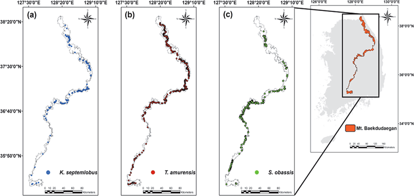
본 연구는 제3차 백두대간 자원실태조사(2016~2020) 자료를 바탕으로 밀원식물 중에서 출현빈도가 높은 음나무, 피나무 그리고 쪽동백나무의 분포지점(음나무 167개, 피나무 539개, 쪽동백나무 359개)을 추출하였다(Figure 1). 제3차 백두대간 자원실태조사는 백두대간을 대상으로 자연 환경 조사의 활용 가치를 증진하고 개선 방안을 도출하기 위해 산림청이 지난 2006년부터 5년 단위로 실시하며, 백두대간을 중심으로 좌우 일정 범위(50 m)를 5개 권역으로 구분하여 백두대간 보호지역의 자연 환경(물리적 환경, 식물상, 동물상, 산림자원)과 인문 환경(역사문화 자원, 인문사회 환경)에 대해 조사·분석한다(Korea Forest Service, 2011; Shin et al., 2016; Korea Forest Service, 2020).
Figure 1.
Contemporary distribution maps of (a) Kalopanax septemlobus (b) Tilia amurensis (c) Styrax obassis based on the 3rd Natural Resources Change Survey of the Baekdudaegan Mountains in South Korea.
Download Original Figure
밀원수 3종의 서식지 적합성 분석을 위해 기후변수인 연평균 강수량, 연평균 온도, 태양복사량과 4개의 지형변수인 고도, 경사도, 지형위치지수(Topographic position index; TPI), 지형습윤지수(Topographic wetness index; TWI) 등 우리나라 식물종 분포에 중요한 영향을 미치는 7개의 변수들을 사용했다(Chun et al., 2015, Table 1). 지형변수는 3차원 지형 자료인 수치고도모델(Digital elevation model; DEM)을 이용해 경사와 주변 지형에 따라 돌출과 함몰 정도를 수치화시킨 TPI(Weiss, 2001), 경사를 이용해 지형에 따른 토양 수분함량을 수치화시킨 TWI를 산출했으며(Kopecký et al., 2021), 이때 TPI와 TWI의 산출식은 다음과 같다.
Table 1.
Description of climatic and topographic variables used for MaxEnt models.
| Classification |
Description |
Abbreviation |
| Climate |
Mean annual precipitation |
MAP |
| Mean annual temperature |
MAT |
| Solar radiation |
Sun |
| Topography |
Elevation |
Elevation |
| Slope |
Slope |
| Topographic position index |
TPI |
| Topographic wetness index |
TWI |
Download Excel Table
여기서 TPI의 M0는 평가 중인 지점의 고도를 말하며, Mn은 주변 인접한 지점의 평균 고도를 말한다(Vinod, 2017). TWI의 a는 단위 등고선 길이당 계곡부를 통해 배수되는 지점의 오르막 경사의 면적을 말하고 tanb는 라디안 단위의 경사 각도를 말한다(Arheimer et al., 2011). 기후변수는 국립산림과학원에서 제공한 디지털 기후지도를 사용하여 산출하였다(Lee and Kim, 2018). 산출된 7개의 환경변수간 다중공선성(Multicollinearity)을 제거하기 위해 Pearson의 상관관계분석을 실시하였으나 변수 간의 상관계수가 모두 0.7 이하로 나타나 7개의 변수를 모두 추출하였다(Lee et al., 2021, Table 2). 각 환경변수에 대한 추출은 ArcGIS 10.5 프로그램을 이용하였으며, 통계 분석은 R studio 4.0.3을 활용하였다.
Table 2.
Summary of the indices of climatic and topographic variables for honey tree species such as Kalopanax septemlobus, Tilia amurensis and Styrax obassis. Abbreviations: Min, minimum; Max, maximum; SD, standard deviation; TPI, topographic position index;, TWI, topographic wetness index; MAT, mean annual temperature; MAP, mean annual precipitation; Sun, solar radiation; n, sample size.
| Variables |
Kalopanax septemlobus (n = 167)
|
Tilia amurensis (n = 539)
|
Styrax obassis (n = 359)
|
| Min |
Max |
Mean |
SD |
Min |
Max |
Mean |
SD |
Min |
Max |
Mean |
SD |
|
Topographic Variables
|
| Elevation |
267 |
1663 |
943.13 |
235.32 |
386 |
1579 |
1016.58 |
219.64 |
203 |
1311 |
702.21 |
182.19 |
| Slope |
2.72 |
51.82 |
19.57 |
9.17 |
1.22 |
51.82 |
18.63 |
8.68 |
0.75 |
42.91 |
19.69 |
8.11 |
| TPI |
–15.25 |
13.13 |
0.96 |
4.38 |
–15.5 |
18 |
1.26 |
4.12 |
–18.75 |
12.13 |
0.16 |
4.23 |
| TWI |
3.73 |
14.3 |
5.56 |
1.68 |
3.64 |
14.29 |
5.47 |
1.39 |
3.65 |
15.40 |
5.97 |
2.15 |
|
Climatic Variables
|
| MAP |
1219 |
2097 |
1541.49 |
185.84 |
1204 |
2180 |
1616.25 |
211.95 |
1219 |
2173 |
1493.83 |
151.64 |
| MAT |
5.8 |
11.8 |
8.5 |
1.15 |
53 |
112 |
80.74 |
11.53 |
6.5 |
11.8 |
9.61 |
0.87 |
| Sun |
741.09 |
1707.82 |
1239.73 |
251.83 |
687.09 |
1707.82 |
1188.30 |
247.67 |
722.09 |
1709.82 |
1265.65 |
232.19 |
Download Excel Table
2. 서식지 적합성 종분포 모형
백두대간 보호구역 내 서식하는 밀원수 3종에 대한 잠재적 서식지 분포와 분포에 영향을 미치는 주요 환경변수를 파악하기 위해 MaxEnt 모형을 사용하였다. MaxEnt 모형은 기계학습식 모형 중 하나로 출현자료만을 적용할 때 다른 모형에 비해 높은 예측 정확도를 나타내는 것으로 보고 되었다(Phillips et al., 2006; Seo et al., 2008; Song and Kim, 2012). 또한 무질서 혹은 불완전한 데이터를 극대화해 값을 추정할 수 있는 모형으로 알려져있다(Cho et al., 2015). MaxEnt 모형의 접근 방식은 종분포 데이터와 중첩된 환경인자와 전체 주어진 환경인자 데이터의 셀 위치와 비교해 샘플링 지점에서 가장 균일한 분포와 위치를 추정한다(Grendár, 2001; Phillips et al., 2004; Phillips et al., 2006). 이를 최대 엔트로피(Maximum Entropy) 알고리즘이라 하며, 분석된 모델은 확률 분포 값으로 결과가 나타난다(Phillips et al., 2006). 본 연구에서는 이러한 최대 엔트로피 알고리즘을 기반으로 백두대간 보호구역 내 서식하는 밀원수 중 음나무, 쪽동백나무 그리고 피나무의 서식지 분포 데이터와 환경인자 데이터를 이용하여 5개의 랜덤 위치정보와 함께 5번의 반복으로 분석이 이루어졌으며 모델의 설명력 검증은 ROC(Receiver Operating Characteristic) 곡선의 AUC(Area Under the Curve) 값을 활용하였다. 또한 백두대간 보호구역 내 밀원수의 잠재적 서식지 분포 패턴을 파악하기 위해 적합도 확률별로 범주를 나누어 면적을 산출했다(Lee et al., 2021, Table 3).
Table 3.
The legend of habitat suitability.
| Legend |
Habitat suitability (%) |
| Best suitable area for habitat |
0.8-1.0 |
| High suitable area for habitat |
0.6-0.8 |
| Moderate suitable area for habitat |
0.4-0.6 |
| Low suitable area for habitat |
0.2-0.4 |
| Unsuitable area for habitat |
0.0-0.2 |
Download Excel Table
각 수종의 서식지 분포를 결정하는 환경인자에 대한 중요성과 반응곡선은 Jackknife 검정을 이용해 도출했다. Jackknife 분석은 서식지 예측 모델을 샘플링할 경우 특정 변수를 생략한 상태로 샘플링을 시작한다(Baldwin, 2009). 즉, MaxEnt 모형에 입력한 변수 중 각각의 변수를 하나씩 제외하여 모델을 실행하는 분석이다(Baldwin, 2009). 이에 따라 개별 변수가 종 분포에 어떤 방식으로 영향을 미치는지에 대한 반응곡선을 나타낼 수 있으며 모델에 대한 개별 변수의 중요성(With only variable)과 변수가 제외될 경우 발생하는 설명력의 감소량(Without variable)을 평가할 수 있다(Yost et al., 2008).
결과 및 고찰
서식지 예측 모형과 설명 검증력인 ROC 곡선과 변수 기여도를 살펴보면, 밀원수 3종에 대한 Training AUC는 음나무 0.8, 피나무 0.803 그리고 쪽동백나무가 0.776으로, Test AUC는 음나무 0.747, 피나무 0.790 쪽동백나무 0.755로 나타났다(Table 4). AUC 값은 0~1의 분포를 나타내며 1에 가까울수록 적합함을 의미하고(Phillips et al., 2006), 종 조사자료에 영향을 받지는 않지만 종의 분포범위에 따라 영향을 받는다고 알려져 있다(Lobo et al., 2008; Park et al., 2016). 또한, AUC 값이 약 0.7 이상일 때, 모형이 설명하는 잠재력이 의미를 갖는다고 판단한다(Lee et al., 2021). 본 연구에서 밀원수 3종에 대한 AUC 값은 모두 0.7 이상으로 MaxEnt에 의한 서식지 예측 모형은 의미를 갖는다고 할 수 있다.
Table 4.
Summary of MaxEnt models for honey tree species such as Kalopanax septemlobus, Tilia amurensis and Styrax obassis. Abbreviation: AUC, area under the curve.
| Species |
Average |
|
Kalopanax septemlobus
|
Tilia amurensis
|
Styrax obassis
|
| Total input samples |
167 |
539 |
359 |
| Training sample |
129 |
424 |
271 |
| Training AUC |
0.8 |
0.803 |
0.776 |
| Test sample |
32 |
106 |
68 |
| Test AUC |
0.747 |
0.790 |
0.755 |
Download Excel Table
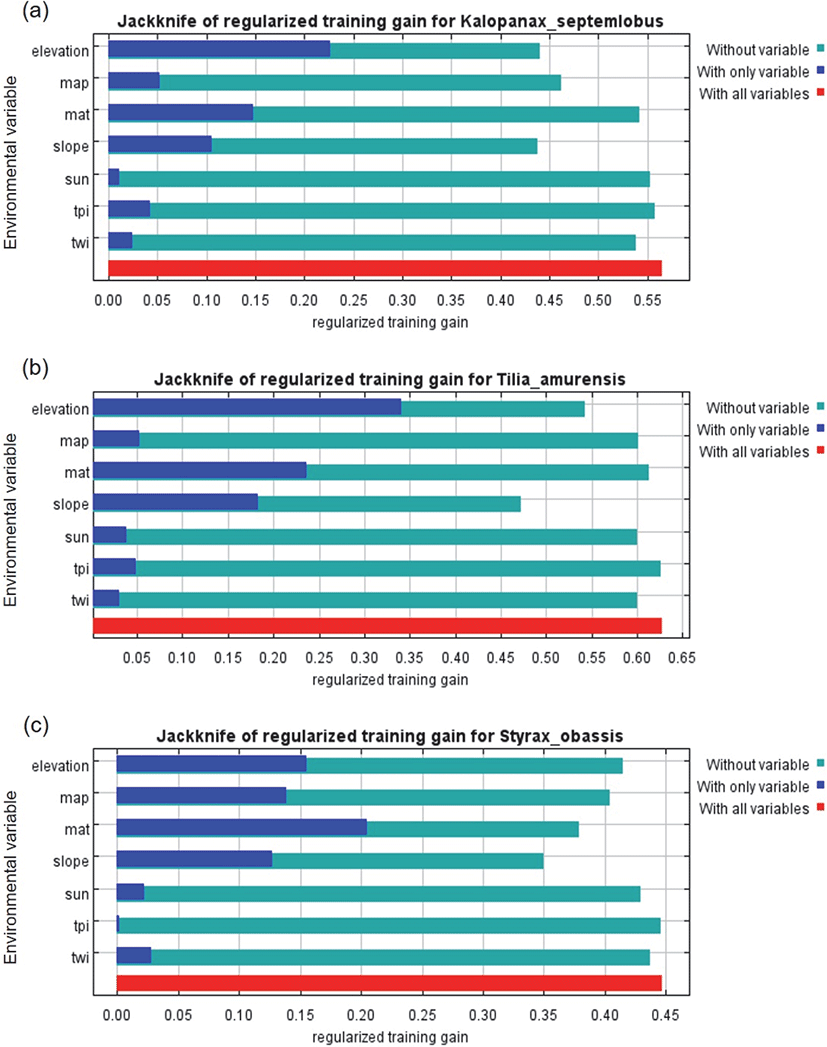
MaxEnt 모형을 통한 밀원수종의 서식지에 영향을 주는 환경변수의 Jackknife 그래프는 Figure 2와 같다. Jackknife 그래프는 각 밀원수종의 서식지 분포 결정과 관련된 7가지 변수의 상대적 중요성을 나타낸다(Lee et al., 2021). Jackknife 그래프에 따른 음나무의 서식지 분포에 관여하는 환경변수는 고도, 연평균 기온 그리고 경사도 순으로 나타났다. 피나무의 서식지 분포에 관여하는 환경변수 역시 음나무와 마찬가지로 고도, 연평균 기온, 경사도 순으로 나타났다. 반면 쪽동백나무의 서식지 분포에 관여하는 환경변수는 연평균 기온, 고도, 연평균 강수량 순으로 나타나 앞선 두 수종과 확연한 차이를 보였다. 본 연구에서 분석된 대상 수종 모두 지형인자인 고도와 기후인자인 연평균 기온이 가장 중요한 인자로 나타났다. 최근 종분포모형과 관련된 연구 중, 한반도 특산식물인 개느삼의 서식지 예측 분석 결과값을 보면, 연간 강수량과 토양이 서식지 적합도와 관련하여 영향을 주는 것으로 밝혀졌다(An et al., 2021). 또한, 금강초롱꽃을 대상으로 분석한 결과값은 해발고도, 연간 강수량, 생장기 평균 강수량, 최한월 평균 기온이 출현 확률에 영향을 미치는 것으로 알려졌고(Sung et al., 2018), 단풍잎돼지풀에 가장 높은 기여를 하는 변수는 해발고도, 경사로 보고된 바 있다(Park et al., 2017). 기존 연구 결과에서 서식지 적합성 분석에 높은 설명력을 가진 것으로 주로 선정된 변수는 강수량, 고도, 경사도 등이었다. 본 연구 대상종인 음나무, 피나무 그리고 쪽동백나무 역시 기존 연구들과 유사하게 가장 큰 영향을 주는 변수는 고도와 기온 인자인 것으로 나타났다. 이는 고도가 우리나라에서 기후인자와 함께 식물 분포 패턴을 제어하는 가장 중요한 인자인 것을 뒷받침해주는 예시로 판단되며, 연평균 기온 역시 식물의 서식지 분포를 제어한다는 기존의 선행연구를 뒷받침해주는 사례이다(Hawkins et al., 2003; Rowe, 2009; Lee and Kim, 2018).
Figure 2.
The relative importance (training gain) of 7 variables for (a) Kalopanax septemlobus (b) Tilia amurensis and (c) Styrax obassis. Abbreviations: map, mean annual precipitation; mat, mean annual temperature; sun, solar radiation; tpi, topographic position index; twi, topographic wetness index.
Download Original Figure
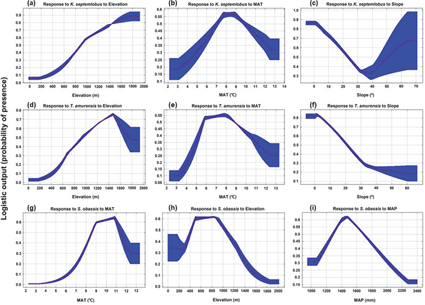
주요반응곡선 결과를 보면, 음나무[Figure 3(a)∼(c)]는 해발고가 높아질수록 서식지 적합도가 증가하는 것으로 나타났으며, 연평균 기온 8~9℃ 에서 높은 서식지 적합도를 보였고 기온이 증가하면 서식지 적합성이 떨어지는 것으로 나타났다. 경사는 40°를 기준으로 서식지 적합성이 떨어지다 증가하는 양상으로 나타났다. 음나무 자생지 입지환경 조사 결과를 본 연구의 결과와 비교하면, 고도에선 주요 서식지로 보고된 780~1300 m 보다 넓은 고도 분포범위인 400~1800 m에서 출현하였다(Kang and Lee, 1998; Lee et al., 2000). 그러나, 이러한 결과는 높은 고도 그리고 급경사지에 분포하는 것을 선호하기보다는 음나무의 새싹은 식용으로 수피는 민간이나 한방에서 약재로 쓰이며, 목재로서 가치도 높아서(Porzel et al., 1992; Kang and Lee, 1998; Hong et al., 2001; Hong, 2002), 이에 따른 수요증대로 무분별한 남획이 성행되어 자생지가 파괴된 결과(Lee et al., 2000)로 생각된다.
Figure 3.
Response curves of variables affecting MaxEnt prediction; (a-c) Kalopanax septemlobus, (d-f) Tilia amurensis and (g-i) Styrax obassis. Abbreviations: MAP, mean annual precipitation; MAT, mean annual temperature.
Download Original Figure
피나무[Figure 3(d)∼(f)]는 음나무와 마찬가지로 400∼1400 m 사이에 분포 적합성이 증가하였으나 그 후 떨어지는 것으로 나타났다. 연평균 기온은 6∼8°C 사이에 서식지 적합도가 증가하는 것으로 나타났고, 8°C 부터는 서식지 적합성이 감소하는 양상을 나타내었다. 경사는 평탄지(경사도 5° 미만)에서 서식지 적합도가 높게 나타났으며 경사가 급할수록 서식지 적합도가 떨어지는 것으로 판단되었다. 피나무는 본 연구의 분포 범위인 400∼1400 m 사이에 분포 적합성이 증가하였는데 기존 선행연구에서 피나무가 해발 1,000 m 지점에 군락을 이루고 있는 것과 유사하게 나타났으며(Hong, 2002), 이는 임산연료, 가구재, 연필재, 조각재와 수피를 쓰기 위해 남벌 및 도벌에 의한 것으로 판단되고 천연갱신이 어려워 벌채한 만큼의 후계수를 이어가지 못할 뿐만 아니라 단순한 용재수 생산을 위한 조림으로 인해 피나무에 대한 적절한 관리가 이루어지지 않은 결과로 판단된다(Hong, 2002).
쪽동백나무[Figure 3(g)∼(i)]는 연평균 기온이 5°C 부터 점차 증가하여 11°C 부터는 서식지 적합도가 떨어지는 것이 확인되었다. 해발고도는 300∼500 m까지 증가하였다가 600 m에서 점차 감소하였고 800 m부터는 서식지 적합도가 떨어지는 것으로 나타났다. 연평균 강수량은 1100 mm 이상부터 서식지 적합도가 상승하였고, 1400 mm부터 감소하는 추세가 나타났다. Kim et al.(2015b)은 소나무-쪽동백나무 군락이 해발 570 m에 분포한다고 밝혔으며, Park et al.(2019)은 쪽동백나무가 고도 600 m 미만에서 중요치가 높게 나타났다. 이는 본 연구의 결과 중 쪽동백나무의 서식지 적합 고도에 대한 반응곡선과 일치한다.
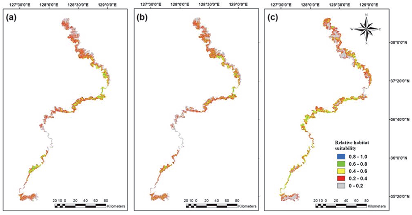
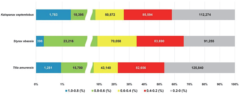
밀원수 3종에 대한 서식지 분포를 파악하기 위해 5가지 기준을 나누어 각 범주별 면적을 계산하였다(Figure 4). 그 결과, 서식지로 아주 적합(0.8∼1.0)하거나 적합성이 높은 지역(0.6∼0.8)은 음나무 7.5%, 피나무 6.3% 그리고 쪽동백나무는 8.7%로 나타났다. 반면에 서식지 부적합(0.2 이하) 또는 낮은 지역(0.2∼0.4)은 음나무 73.7%, 피나무 77.6% 그리고 쪽동백나무는 65.2%를 차지하였다(Figure 5). 밀원수 3종이 대부분 대규모 군락 형태로 자생하기보다는 단목 또는 소수의 개체 집단으로 분포하기 때문에, 주요 밀원 자원으로 이용하기 위해서는 이들에 대한 집중적 관리와 치수 유도 그리고 필요시 적합한 서식지에 조성이 필요하다. 본 연구는 이러한 주요 밀원 자원들의 적절한 이용과 조성을 위한 적합지에 대한 의미 있는 결과를 제공한다.
Figure 4.
Potential distribution maps of three honey tree species; (a) Kalopanax septemlobus, (b) Tilia amurensis, (c) Styrax obassis.
Download Original Figure
Figure 5.
Proportions of potential distributional areas of three honey tree species based on suitability values from MaxEnt model. The numbers in the graph represent the area in hectares.
Download Original Figure
본 연구는 종분포모형을 이용하여 밀원수 3종에 대한 서식지 적합성을 백두대간 보호구역에 적용한 연구로서 의의가 있다. 이러한 결과는 우리나라의 생태축인 백두대간을 포함하여 전국단위의 밀원수종에 대해 객관적 평가를 하는 데 있어 활용될 수 있다. 하지만 본 연구에서 활용한 백두대간 자원실태조사 데이터는 백두대간 능선부 조사 자료이다. MaxEnt 모형이 출현자료만을 이용할 때 다른 서식지 적합 모형보다 우수하다는 장점이 있지만(Phillips et al., 2006), 능선부의 데이터만으로 보호구역 전체의 서식지 적합성을 예측하는 것은 능선부 환경을 중심으로, 편향된 결과를 나타낼 수 있다는 한계점이 존재한다. 또한 서식지 적합성을 파악하기 위해 사용된 환경변수의 선정에 있어 식물의 서식지를 결정하는 지형인자와 기후인자가 사용이 되었다. 기존의 많은 연구에서 서식지 적합 모형을 도출하기 위해 사용된 환경인자는 Worldclim의 1 km의 해상도를 가지고 있는 Bioclim과 고도를 사용하였다(Lee et al., 2015; An et al., 2021; Lee et al., 2021). 본 연구는 이러한 선행연구들보다 고해상도인 30 m 해상도의 데이터를 사용하여 선행연구의 한계점을 극복했다. 그러나 토양조건, 개체군 크기에 따른 입지조건, 생물상에 의한 환경 변화 등 식물의 서식지 결정에 많은 영향을 미치는 다양한 환경, 생물학적 인자를 반영하지 못했다. 이는 국내의 고해상도의 데이터가 존재하지 않기 때문에 식물의 서식지 분포 예측모형에 있어 여전히 지형인자와 기후인자만을 사용하고 있다는 한계점을 가지고 있다. 따라서 향후 이러한 인자들을 반영하여 추가적인 분석과 모델 구축이 이루어져야 할 것이다.
결 론
본 연구에서는 제3차 백두대간 자원실태조사 자료를 바탕으로 출현 빈도가 높은 밀원수종 3종에 대해 서식지 적합성을 분석하였고, 이를 위해 밀원식물의 서식지 분포에 영향을 미치는 인자들을 수집하여 평가하였다. 분석 결과, 밀원수종 3종 모두 지형적인 요소인 고도와 기후 요소인 기온 인자에 영향을 받는 것을 알 수 있다. 생태적 특성들과 생물기후변수 및 다른 환경변수를 고려하여 밀원수종 분포를 예측하는 것은 밀원수 보전 및 관리방안에 있어 매우 중요한 데이터가 될 것으로 생각한다. 또한 본 연구는 서식지 관리 및 복원, 개체군이나 군집, 생태계의 모형화, 생태계 복원, 종이나 생태계에 대한 기후변화 효과 예측 등과 같은 자원관리 및 보전계획에 다양하게 활용될 수 있어 이에 관한 종합적인 연구가 장기적으로 수행되어야 할 것이다.
그러나 본 연구는 백두대간 내 밀원수 분포를 설명하기에 조사된 종분포 데이터의 범위가 백두대간 마루금으로 제한되어 있는 한계점이 있다. 비록, MaxEnt 모형이 일부 출현자료를 이용할 때 다른 모형보다 서식지 예측이 높다는 장점이 있지만, MaxEnt 모형의 신뢰성을 높이고 백두대간 내 밀원수의 정확한 서식지 분포를 예측하기 위해, 향후 백두대간 마루금 뿐만 아니라 보호구역 내 밀원수의 출현정보에 대한 조사가 진행되어야 할 것으로 판단된다. 또한 본 연구를 포함한 많은 서식지 적합 모형 연구들에서 사용된 기후인자나 지형인자는 국내·외에서 구축된 비교적 높은 해상도를 가진 데이터를 기반으로 이루어지고 있다. 그러나, 토양의 이화학적 특성, 건조도 등 높은 해상도를 가지고 있지 않은 데이터나, GIS 데이터 기반이 구축되어 있지 않은 무생물적인자 또는 종내·종간경쟁, 천이과정과 같은 생물적 인자들을 반영한 연구는 없는 실정이다. 즉, 대부분의 연구가 비교적 용이하게 데이터를 확보할 수 있는 기후와 지형인자들을 설명변수로 한정시키고 있어 적합하고 정확한 서식지 예측을 위해 앞서 제시한 다양한 환경 및 생물학적 변수들을 반영한 통합적 분석이 필요할 것이다. 또한, 밀원수 서식지 적합성을 전국단위인 국가산림자원조사 또는 환경부의 전국자연환경조사 데이터에 적용시켜 향후 밀원단지 조성에 대한 기초자료로서의 가치가 있다고 판단된다.
감사의 글
본 연구는 산림청(한국임업진흥원) ‘산림과학기술 연구개발사업(2021362C10-2123-BD01)’ 그리고 산림청 ‘백두대간 자원실태변화조사 및 관리방안 연구(2016-20)(과제번호: 00208006800)’의 지원에 의해 이루어진 것입니다.
References
An, J.B., Sung, C.Y., Moon, A.R., Kim, S., Jung, J.Y., Son, S., Shin, H.T. and Park, W.G. 2021. Distribution and potential suitable habitats of an endemic plant,
Sophora koreensis in Korea. Korean Journal of Environment and Ecology 35(2): 154-163.


Arheimer, B., Dahne, J., Lindstrom, G., Marklund, L. and Stromqvist, J. 2011. Multi-variable evaluation of an integrated model system covering Sweden (S-HYPE). IAHS-AISH Publication 345(1): 145-150.
Baldwin, R.A. 2009. Use of maximum entropy modeling in wildlife research. Entropy 11(4): 854-866.
Cho, H.J., Kim, D.H., Shin, M.S., Kang, T. and Lee, M. 2015. Predicting the goshawk's habitat area using species distribution modeling: case study area Chungcheongbuk-do, South Korea. Korean Journal of Environment and Ecology 29(3): 333-343.
Cho, N., Kim, E.S., Lee, B., Lim, J.H. and Kang, S. 2020. Predicting the potential distribution of
Pinus densiflora and analyzing the relationship with environmental variable using MaxEnt model. Korean Journal of Agricultural and Forest Meteorology 22(2): 47-56.
Chun, J.H., Lee, C.B. and Yoo, S.M. 2015. Shifts of geographic distribution of
Pinus koraiensis based on climate change scenarios and GARP model. Korea Journal of Agricultural and Forest Meteorology 17(4): 348-357.
Chung, Y.H. 1984. Flowering process and pollination mechanism of Genus Tilia in Korea. Journal of Plant Biology 27(3): 107-127.
Elith, J., Kearney, M. and Phillips, S. 2010. The art of modelling range‐shifting species. Methods in Ecology and Evolution 1(4): 330-342.
Fritsch, P. 2004. Styracaceae. Flowering Plants·Dicotyledons. Springer. pp. 434-442.
Gonsoulin, G.J. 1974. A revision of Styrax (Styracaceae) in North America, Central America, and the Caribbean. SIDA, Contributions to Botany 5(4): 191-258.
Grendár, M. 2001. Maximum entropy: Clearing up mysteries. Entropy 3(2): 58-63.
Guisan, A. and Zimmermann, N.E. 2000. Predictive habitat distribution models in ecology. Ecological Modelling 135 (2-3): 147-186.
Han, J., Kang, M., Kim, S., Lee, K. and Baik, E. 2009. Flowering, honeybee visiting and nectar secretion characteristics of
Robinia pseudoacacia L. Suwon, Gyeonggi province. Journal of Apiculture 24(3): 147-152.
Han, J. and Kim, S. 2008. Flowering and nectar secretion characteristics of honey plant,
Hovenia dulcis var.
koreana Nakai. Journal of Apiculture 23(3): 199-205.
Hawkins, B.A., Field, R., Cornell, H.V., Currie, D.J., Guégan, J.F., Kaufman, D.M., Kerr, J.T., Mittelbach, G.G., Oberdorff, T. and O'Brien, E.M. 2003. Energy, water, and broad‐scale geographic patterns of species richness. Ecology 84(12): 3105-3117.
Hong, S.C. 2002. Forestry policy and the future of honey tree species. Proceedings of the 2002 meeting of Journal of Apiculture 1: 85-100.
Hong, S.S., Han, D.I., Hwang, B.Y., Choi. W.H., Kang, H.S., Lee, M.K., Lee, D.K., Lee, K.S. and Ro, J.S. 2001. Chemical components from the stem barks of
Kalopanax septemlobus. Korean Journal of Pharmacogn 32(4): 302-306.
Hwang, K. 2016. Ecological characteristics and successional trends of forest cover types in the baekdudaegan, South Korea. (Dissertation). Chuncheon. Kangwon National University.
Jo, M.H., Kim, J.B., Jo, Y.W. and Baek, S.R. 2001. Application method of satellite image and GIS for suitability of black locust forest as honey plant area. Journal of the Korean Association of Geographic Information Studies 4(2): 27-37.
Kang, D.Y. 2018. Analysis on honey plants selection for and economic impacts of multi-functional honey plant complex. (Dissertation). Seoul. Seoul National University.
Kang, H.S. and Lee, D.K. 1998. Site and growth characteristics of
Kalopanax septemlobus growing at Mt. Joongwang in Pyungchang-gun, Kangwon-do. Journal of Korean Society of Forest Science 87(3): 483-492.
Kang, J.H., Suh, M.S. and Kwak, C.H. 2009. Classification of land cover over the Korean Peninsula using MODIS data. Atmosphere 19(2): 169-182.
Khuroo, A.A., Weber, E., Malik, A., Reshi, Z.A. and Dar, G. 2011. Altitudinal distribution patterns of the native and alien woody flora in Kashmir Himalaya, India. Environmental Research 111(7): 967-977.
,

Kim, M.S., Kim, H.S., Kim, S.D., Park, S.J., Song, J.H. and Kim, S.H. 2015a. Pollinator visit, characteristics of secreted nectar and analysis of nectar sugar and amino acid contents in flower of
Dendropanax morbifera Lev. Journal of Apiculture 30(4): 307-314.
Kim, D.H., Kim, S.H. and Oh, C.H. 2015b. Ecological characteristic in communities of
Pinus densiflora at the Mt. Baekdudaegan -Between Cheonghwasan and Namdeogyusan-. Korean Journal of Environment and Ecology 25(2): 69.
Kim, H.G., Lee, D.K., Mo, Y.W., Kil, S.H., Park, C. and Lee, S.J. 2013. Prediction of landslides occurrence probability under climate change using MaxEnt model. Journal of Environmental Impact Assessment 22(1): 39-50.
Kim, J.Y., Kwon, H.S., Seo, C.W., Ryu, J.E. and Kim, M.J. 2012. A study on the species distribution modeling using national ecosystem survey data. Journal of Environmental Impact Assessment 21(4): 593-607.
Kim, M.S., Kim, S.H., Han, J., Kang, M.S. and Park, Y. 2011. Honeybee visiting and nectar secretion characteristics of
Crataegus pinnatifida Bunge, Chinese Hawthorn. Journal of Apiculture 26(1): 11-14.
Kim, M.S. 2021. A study on the valuation of four major honey-source trees. (Dissertation). Chuncheon. Kangwon National University.
Kim, T.W. and Lee, Y.M. 1989. The state and propagation plans of honey plants in Korea. Journal of Apiculture 4(1): 9-18.
Kim, Y.K., Kim, S.H., Kim, M.S., Yun, A.Y., Park, I.H. and Go, Y.S. 2018. Flower morphological characteristics and classification of selected population of
Sorbus alnifolia (Siebold and Zucc.) K. Koch. Journal of Apiculture 33(3): 157-163.
Kopecký, M., Macek, M. and Wild, J. 2021. Topographic wetness index calculation guidelines based on measured soil moisture and plant species composition. Science of The Total Environment 757: 143785.
,
Korea Forest Service. 2011. Survey Report about Resources in BDMS. pp. 247.
Korea Forest Service. 2020. Natural Resources Change Survey and Management Practice Study of the Baekdudaegan Mountains. pp. 18.
Kwon, H.S., Ryu, J.E., Seo, C.W., Kim, J.Y., Lim, D.O. and Seo, M.S. 2012. A study on distribution characteristics of
Corylopsis coreana using SDM. Journal of Environmental Impact Assessment 21(5): 735-743.
Lee, C.H., Choi, Y.C., Kim, S.H. and Kwon, K.W. 2000. Site characteristics, and vegetation structure, and dynamics of forest communities growing
Kalopanax septemlobus (Thunb. ex Murray) Koidz. Gangwon-do. Korean Journal of Plant Resources 13(3): 227-242.
Lee, C.B., Chun, J.H. and Kim, H.H. 2013. Elevational pattern and determinants of α and β plant diversity on the ridge of the baekdudaegan mountains, South Korea. Journal of Agriculture and Life Science 48(3): 93-104.
Lee, C.B. and Kim, H.H. 2018. Elevational patterns of plant species richness and relative importance of climatic and topographic factors on the Mt. Seorak, South Korea. Journal of Agriculture and Life Science 52(3): 1-11.
Lee, M.K., Chun, J.H. and Lee, C.B. 2021. Prediction of distribution changes of
Carpinus laxiflora and
C. tschonoskii based on climate change scenarios using MaxEnt model. Korean Journal of Agricultural and Forest Meteorology 23(1): 55-67.
Lee, Y.H., Oh, Y.J., Hong, S.H., Na, C.S., Na, Y.E., Kim, C.S. and Sohn, S.I. 2015. Predicting the suitable habitat of invasive alien plant
Conyza bonariensis based on climate change scenarios. Journal of Climate Change Research 6(3): 243-248.
Lim, C.H., Jung, S.H., Jung, S.Y., Kim, N.S. and Cho, Y.C. 2020. Selection of optimal models for predicting the distribution of Invasive alien plants species (IAPS) in forest genetic resource reserves. Korean Journal of Environment and Ecology 34(6): 589-600.
Lobo, J.M., Jiménez‐Valverde, A. and Real, R. 2008. AUC: a misleading measure of the performance of predictive distribution models. Global ecology and Biogeography 17(2): 145-151.
Meyer, P. 1992. The snowbells of Korea. Arnoldia 52(1): 2-8.
National Institute of Forest Science. 2009. Actual status of production and distribution of medicinal resources in mountainous areas, pp. 133.
Oh, M.S., Kim, D.L. and Lee, S.H. 2016. History, current status, and discussion on the future vision of
Apis cerana beekeeping in Korea. Journal of Apiculture 31(2): 165-172.
Park, B.J., Byeon, J.G. and Cheon, K.I. 2019. Study of ecological niche and indicator species by landforms and altitude of forest vegetation in Mt. Myeonbong. Korean Journal of Plant Resources 32(4): 325-337.
Park, H.C., Lee, J.H., Lee, G.G. and Um, G.J. 2015. Environmental features of the distribution areas and climate sensitivity assessment of Korean Fir and Khinghan Fir. Journal of Environmental Impact Assessment 24(3): 260-277.
Park, H.C., Lim, J.C., Lee, J.H. and Lee, G.G. 2017. Predicting the potential distributions of invasive species using the Landsat imagery and MaxEnt: Focused on. Journal of the Korean Society of Environmental Restoration Technology 20(1): 1-12.
Park, S.W., Koo, K.A., Seo, C.W. and Kong, W.S. 2016. Potential impact of climate change on distribution of warm temperate. Journal of the Korean Geographical Society 51(2): 201-217.
Philips, S.J., Schapire, R.E. and Dudik, M. 2004. A maximum entropy approach to species distribution modeling. In Proceedings of the twenty-first international conference on Machine learning. pp. 83.
,
Phillips, S.J., Anderson, R.P. and Schapire, R.E. 2006. Maximum entropy modeling of species geographic distributions. Ecological Modelling 190(3-4): 231-259.
Philips, S.J. and Dudik, M. 2008. Modeling of species distributions with MaxEnt: new extensions and a comprehensive evaluation. Ecography 31(2): 161-175.
Porzel, A., Sung, T.V., Schmidt, J., Lischewski, M. and Adam, G. 1992. Studies on the chemical constituents of
Kalopanax septemlobus. Planta Medica 58(5): 481-482.
,
Rowe, R.J. 2009. Environmental and geometric drivers of small mammal diversity along elevational gradients in Utah. Ecography 32(3): 411-422.
Ryu, J.B. 2003. Classification of honey plants in Korea. Journal of Apiculture 18(1): 5-22.
Ryu, J.B. and Jang, J.W. 2008. Newly found honey plants in Korea. Journal of Apiculture 23(3): 221-228.
Seo, C.W., Park, Y.L. and Choi, Y.S. 2008. Comparison of species distribution models according to location data. Journal of Korean Society for Geospatial Information Science 16(4): 59-64.
Shin, M.H., Kim, J.H., Kwon, J., Lim, J.H., Choi, H.T. and Park, C. 2016. Comparison of survey methods and results for natural environment in Baekdudaegan mountain system. Journal of the Korean Society of Environmental Restoration Technology 19(2): 1-18.
Shin, M.S., Jang, R.I., Sea, C.W. and Lee, M.W. 2015. A comparative study on species richness and land suitability assessment - Focused on city in Boryeong -. Journal of Environmental Impact Assessment 24(1): 35-50.
Shin, M.S., Seo, C., Park, S.U., Hong, S.B., Kim, J.Y., Jeon, J.Y. and Lee, M. 2018. Prediction of potential habitat of Japanese evergreen oak (
Quercus acuta Thunb.) considering dispersal ability under climate change. Journal of Environmental Impact Assessment 27(3): 291-306.
Song, W.K. and Kim, E.Y. 2012. A comparison of machine learning species distribution methods for habitat analysis of the Korea water deer (
Hydropotes inermis argyropus). Korean Journal of Remote Sensing 28(1): 171-180.
Song, W.K. 2015. Habitat analysis of
Hyla suweonensis in the breeding season using species distribution modeling. Journal of Korean Society of Environmental Restoration Technology 18(1): 71-82.
Sugden, E.A. 1986. Anthecology and pollinator efficacy of
Styrax officinale subsp.
redivivum (Styracaceae). American Journal of Botany 73(6): 919-930.
Sung, C.Y., Shin, H.T., Choi, S.H. and Song, H.S. 2018. Predicting potential habitat for
Hanabusaya asiatica in the North and South Korean border region using MaxEnt. Korean Journal of Environment and Ecology 32(5): 469-477.
Thuiller, W. 2003. BIOMOD–optimizing predictions of species distributions and projecting potential future shifts under global change. Global Change Biology 9(10): 1353-1362.
Vinod, P.G. 2017. Development of topographic position index based on Jenness algorithm for precision agriculture at Kerala, India. Spatial Information Research 25(3): 381-388.
Weiss, A. 2001. Topographic position and landforms analysis. In Poster presentation, ESRI user conference, San Diego 200.
Yoo, K.J. 2002. An approach for establishing conceptual framework of management spectrum on the Baekdudaegan area, Korean. Korean Society of Environment and Ecology 15(4): 408-419.
Yost, A.C., Petersen, S.L., Gregg, M. and Miller, R. 2008. Predictive modeling and mapping sage grouse (
Centrocercus urophasianus) nesting habitat using Maximum Entropy and a long-term dataset from Southern Oregon. Ecological Informatics 3(6): 375-386.